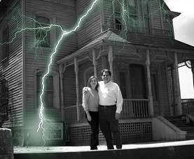
The wind is raging, it’s gotten dark, clouds swirl overhead, and an eerie silence sets in. A storm is brewing. Let’s go storm chasing.
We’ve always been fascinated by the weather, and to go out to see what’s coming at us is instinctual. Once I was out on the road when a powerful storm was heading toward me. In search of a safe place to ride it out, I drove quickly to the nearest small town. Warnings were going off all over the place, but I saw children riding bikes and playing ball while about half the population was sitting on their porches or even setting up lawn chairs in the road to gaze upward in amazement.
But beauty has a beast and a storm is not to be take lightly. They’re unpredictable and fast, and, as we all know too well, they can be very, very destructive.
Also read: The Best Rugged Compact Cameras Right Now!
But let’s go anyway. So where do we start?
First off, we need to find a storm. If you happen to live in the Great Plains, they’ll most likely find you, but not all of us are so lucky. So you have two choices. You could find a professional chaser and book a tour. They usually list their tour dates and starting cities online. You just pick your week, pay some money, and show up for your chance at chasing excitement.
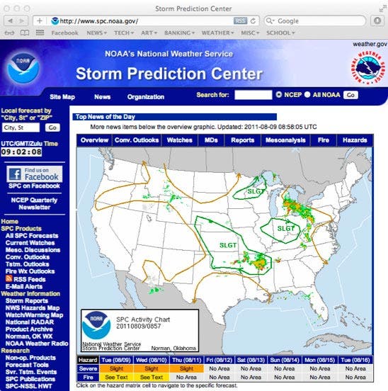
Or you can go it alone. If this is your choice, you have a little planning to do. First, go to the website of Storm Prediction Center, a division NOAA’s National Weather Service (NWS) based in Norman, Oklahoma. Their job is to “provide timely and accurate forecasts and watches for severe thunderstorms and tornadoes over the contiguous United States.” In other words, they’re looking at the United States as a whole, trying to predict where severe weather is going to happen. They’re actually very good at this, and their website provides lots of great information about where storms will be, and what to expect.
You also need to visit the website of your regional National Weather Service office. If you have one near you, go take a tour. Online, they’ll provide the detailed forecast for your area as well as links to Doppler radar, the same as you find on the Weather Channel.
You should also look in to getting a radar app for your mobile device, like the RadarScope app by Base Velocity for iOS devices.
The day finally arrives, and it’s time to go look at some clouds. What should you bring?
- A camera (preferably, a DSLR) with charged battery and extra memory cards;
- A wide-angle lens for getting the whole storm;
- A telephoto zoom to bring you nice and close without having to be in harm’s way;
- A good sturdy tripod. It can be quite dark under a storm cloud, so having a tripod will help ensure your images are sharp and in focus. And if you want to capture some lightning, a tripod is a must;
- A snack. You will get hungry and thirsty;
- A car charger for your phone.
And we’re off!
The first place to stop is the gas station. This might sound trivial, but we don’t want to pull off a storm just as it is getting good because we’re out of gas. And in some parts of the country gas stations might be few and far between.
Now we’re really off. Where to?
You could just head toward the darkest spot in the clouds and wing it, but I wouldn’t recommend this. The beast might be lurking behind a mask of rain, and things can turn ugly fast. Check the latest images from your radar app on your mobile device, and decide where you’re going.
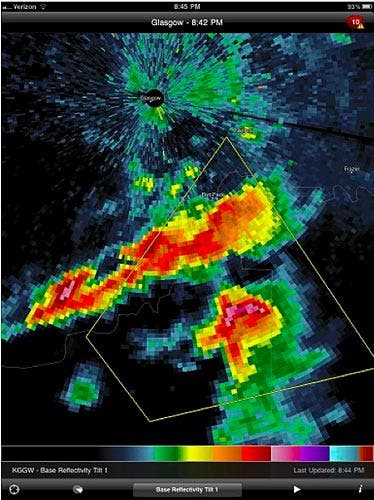
Now this is where some experience and luck come into play. Some radar apps display lots of different modes, but all will provide you with some basic “reflectivity” measurements. This is like the radar a police officer uses to give you a speeding ticket: your little red sports car or falling rain doesn’t register as well as the big semi-truck or the damaging hail. The radar shows you where the strongest parts of the storm are, and that’s what we’re looking for. Besides, the storm data the app has another important advantage: the ability to know our location.
All modern smartphones use GPS location data to tell you where to eat or how to get to a new store that’s opened across town, but in our case this information is being plotted on the radar display showing us where we are in relation to the storm cloud coming towards us. Just pick the place that looks like it’s the strongest and drive to get in front of it.
If getting to the front of the storm requires driving through it keep in mind that big storms pack a punch. You could encounter very heavy rain and strong winds that might have flooded the roads or downed trees or power lines. You have a good chance of encountering hail, some of which might break windows and pound your car to totaled status.
So be safe, and don’t let the pumping adrenaline cloud your judgment.
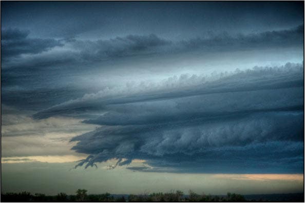
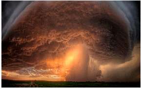
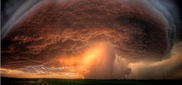
Once you’ve passed those hazards, you’ll be sitting directly in front of a beautiful, awe inspiring storm. It’s photographically perfect.
But before you jump from your car with that metal tripod in hand to run to the steel barbed-wire fence that lines the road directly under the power lines, remember the lessons you learned at age five about lightning.
Do a quick check of your surroundings to see if you’re standing in the best place. Maybe you should be another hundred yards up the road; maybe a hundred yards back. While your chances of getting hit by lightning are greater than those of winning the lottery that’s one prize you don’t want to win. Keep that in mind.
Also read: First Person: Tornado
Take lots of pictures, and be sure to check them from time to time to make sure you’re getting the exposure you want. There’s nothing more frustrating than being on a great chase and getting back home only to find the exposure wasn’t right or that the auto focus was turned off.
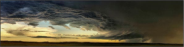
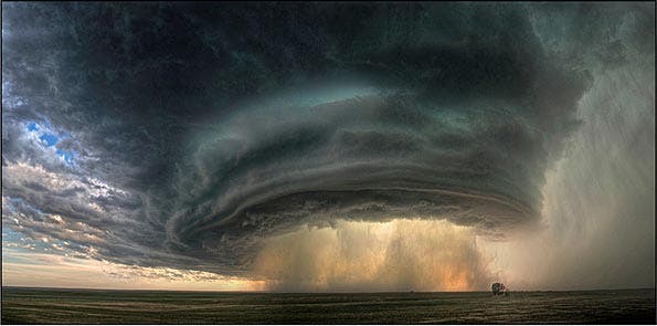
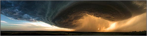
Try to take some panoramas of the storm. They capture the whole storm more effectively. They allow you to contrast the storm’s leading edge of blue sky and puffy white clouds with the raw power of the beast. Most of the newer point-‘n’-shoots and some digital single-lens reflex cameras (DSLRs) have a mode that makes it easy. If not, just turn your camera vertically set your zoom to between 35-50mm and shoot left to right moving the camera between shots. Try to keep the horizon in the same place in each shot and give a little overlap from the last frame to help with later alignment. Also make sure you are in a manual exposure mode or have the exposure locked so that each frame is the same.
Back at the computer, you can try you skills in Photoshop to piece them together or just search the internet for a program that’ll do the work for you. Try some HDR (High Dynamic Range) images. You’re going to have to be fast with these; alignment could be tricky because clouds move rapidly.
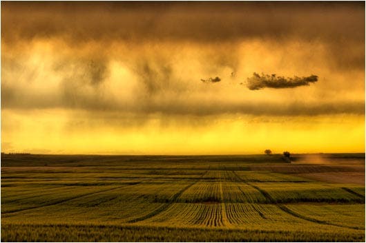
But most importantly, don’t forget to turn around and look behind you. You might just see the perfect photographic composition of a rolling landscape with the sun shining through encroaching storm clouds. It just might be the shot that makes the whole day worthwhile.
When the storm starts getting a little too close just keep moving down the road to stay
in front of it. Be patient and be prepared to wait. Storms are living, breathing things, and they go through cycles. You might come upon a storm that doesn’t look severe but it could be growing. Keep reviewing your radar and visiting the NWS websites to learn of updates to the storm you’re following. Consider becoming SKYWARN trained so you can help relay information about a storm you are chasing to others in your community. Have fun, but keep in the back of your mind that–even with all the knowledge and technology that we have–storms are still unpredictable.
Check out Sean R. Heavey’s web site for more of his stunning weather photos.