


This item is no longer available.
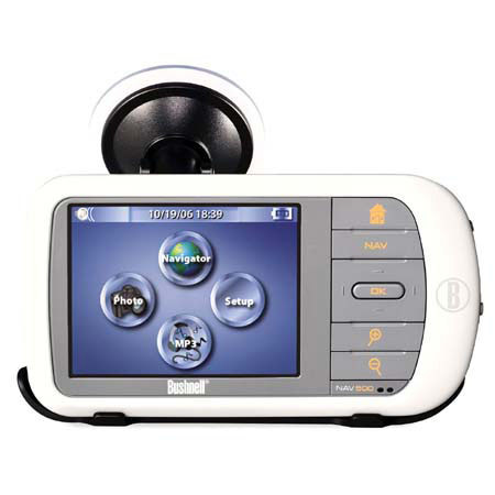
Blame intuition when folks notice your remarkable new ability to arrive on time and unfrazzled via complicated and unfamiliar roadways. Mounted to your dash, our new NAV500 voice-prompts turn-by-turn directions with full-color mapping capability and touch-screen controls.
Zoom Button: Use this to get a more detailed look at your chosen satellite image or aerial photo.
Aerial Photos:
Unlike maps, which portray the landscape with generalized symbols and colors, aerial photography reflects the terrain as it exists in nature. Buildings, bridges, roads, urban and rural areas, and other manmade features are shown as they were at the time of photography.
Georeferenced satellite images:
When you download a satellite or aerial photo to your Bushnell GPS, it's instantly georeferenced to the satellite network for navigation. This means the image is calibrated to adjust to your heading and location to display an accurate representation of the ground you're eXPLORing.
For example:
if you're headed south facing a stand of pines, you can look down at your Bushnell GPS and the satallite image or aerial photo and directional compass will also display you're headed south and facing the stand of pines. We call this TruView navigation. By referencing the landmarks around you to those on your LCD, you can eXPLORe new territory with the competence of someone who's trekked the land for years.
Georeferenced satellite images also give you an accurate portraayal of relative distance when viewing your position in relation to waypoints and visible landmarks. This means, if you know you've traveled nearly a mile from your treestand, and your next stopping point appears to be of equal distance away on your LCD, you can estimate you're approximately a mile from your destination. It's fast, simple and the most efficient way to see the country.
Routes:
A path to an end point consisting of intermediate stops, marked by waypoints, along the way.
SafeTrack battery-conservation mode:
The ONIX runs continuously for up to 39 hours on one set of batteries thanks to SafeTrack. This feature puts the display to "sleep" to save power while maintaining satellite connection behind the scenes. Optional audible alarms alert you of deviation from course.
Bushnell-exclusive screen-layering feature:
It's how we made the world's most advanced GPS so easy to use. Bushnell GPS units layer a satellite or aerial photo, or a topographic map, and all navigational aids in perfect harmony on a single screen.
Topographic Maps: Shows the grade and elevation data for a certain part of the earth, in addition to other physical and manmade features.
WAAS:
Wide Area Augmentation Systems. This is a network of satellites and ground stations providing GPS signal connections that enhance accuracy. Your Bushnell GPS has a WAAS-enabled receiver accurate to 3 meters 95% of the time.