2011-03-12T19:00:00
Rated 2 out of 5
Geomet'r Real Time Geotagging GPS RX
Geomet'r Real Time Geotagging GPS Receiver works as advertised but the cable connection to the device is a weak point. My unit began to fail intermittently and I found that by moving the cable around I could get the device working, but the wiring eventually broke.
Khunchy
2010-02-20T19:00:00
Rated 4 out of 5
Works Well
Works as advertised, put it on and it tells you rightaway your location
Bob
2010-02-13T19:00:00
Rated 1 out of 5
Good effort but poor quality
The ability to geo-tag photos is brilliant. I purchased two of these (for my Nikon D200 & D700) both units died within the first 6 months of use. I do quite a bit of air travel so I'm not sure if over time airport x-ray scanners have had some kind of cumulative impact. I now have a Nikon GP-1 (4 months now) and although it has not gone through airport scans it seems to be working fine so far.
R W.
2009-08-15T21:00:00
Rated 3 out of 5
Problems with software on OS X Platform
The unit is easy to use as far as data aquisition with Nikon D300, but lacking battery replacement instructions in user guide. The software doesn't recognize 12MB raw files in folders. I'm using MAC OS 10.4.11 platform.
I haven't been able to use folder data to find coordinates for even one or two shots let alone higher volumes. If anyone who reads this has a suggestion, please let me know. I know I must be doing something wrong here, because data shows up in camera and in my MobleMe info
Buzzclik
2009-07-07T21:00:00
Rated 2 out of 5
It worked with quirks on my D200.
I recently took an Alaskan 7 day cruise. Thinking that it would be nice to have the GPS coordinates embedded into the photo info; this unit happened to go on sale (I took that as a sign) so I ordered it.
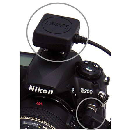
Installation was simple. There is a plastic "H" mount for the flash shoe. Some velcro and it's mounted. The 10 pin cable then plugs in to the outlet on the left/ (as you're holding the camera) front of the camera. The head fits in only one way and then you gently screw in the locking ring. I saw in some other comments that it was difficult with large fingers. I don't have large fingers and attached it easily enough but I would sure hate to have to do this in a hurry. It does require patience and finesse.
When I turned on my D200, I could see the letters "GPS" blinking just to the left of the battery charge meter. With a clear overhead, it took about 90 seconds to get signal lock which is indicated when it stops blinking and remains solid. During the times that I had a partially obstructed overhead (standing on the balcony of my room), it took about 4 minutes to get a lock but it eventually did.
After that, just snap away. After the shot, you can scroll through the embedded information and you will see the latitude, longitude, and elevation listed. I compared the information with my Garmin 60CSx GPS unit and it was close enough to not worry about. So I was very satisfied with its accuracy.
The program that comes with the unit is very easy to use. Once it's on your computer, start it, search for a photo you wish to view and then select. If you have internet, it will find the Google map showing the location that the picture was taken at. If you select a series of photos, you can plot your route. I thought it was cool.
Now for the problems, shortly after I began using it, my D200 began to malfunction. I would turn it on but none of the controls worked. I found that I could just turn off the camera, turn it back on, and it worked then. If I let my camera sit idle for a while, it would lock up. But simply turning it off and then back on solved it.
Towards the end of the cruise, my D200 began to give me exposures problems so I stopped using the unit. The exposure problems I encountered were that my D200 on "P" would blow out (over expose) the first shot, under expose the second, and the third would be spot on.
Now my D200 is 3 years old and has been coast to coast a few times so it might be getting worn out. But since I was on a cruise; did not bring a back up camera, and it was almost at the very end of the cruise - I didn't take any more chances. I have not used it since our return nor have I had any further recurrence of those problems. I am glad that I do have the GPS coordinates embedded in my photo and think it worth it. But not knowing if it was just my camera or whether it could lead to permanent damage, I can't recommend it.
Some other reviews noted that the battery life was significantly reduced. I found this to be very true. Typically without flash, I can get almost 1,000 shutter actuations on one fresh battery charge. With the GPS unit running, it seemed more like 250. At times it seemed like you could stand there and watch the battery charge fall. I'm glad I brought a spare battery with me and while we were at the glaciers, I was literally rotating between the two every 2 hours.
RANDALL W.
2009-04-08T21:00:00
Rated 5 out of 5
Geomet'r DSLR GPS
It is easy to install and use. It works extremely well.
MorgothJEV
2009-03-29T21:00:00
Rated 5 out of 5
Geomet'r DSLR GPS
I compare this DLSR GPS with others, read many user reviews and reviews from photography magazines.
This product had all of the features that I needed.
Jim
2009-03-24T21:00:00
Rated 4 out of 5
One of my favorite camera accessories!
This is a great product. I use with a D700 & D200. Overall an excellent product that I would recommend particularly if you travel or take photos in remote locations.
Goods:
- The GPS can be left on regardless of camera power setting. This allows the GPS to maintain a sattalite lock without having to re acquire between photos.
- Power consumption is very low. I noticed negligable difference shooting all day with my D700.
- Less expensive than the Nikon GP-1.
- Uses good velcro strips to easily adjust the position of the receiver on the hot shoe to avoid interferance with the pop up flash.
Bads:
- Difficult to plug in the cable if you have thick fingers(Partly due to Nikon's placement of the 10-pin plug).
- Potential to loose the 10-pin plug cap on the D200 and other models that dont have the integrated plug cap.
- No software included to help plot photo locations on maps.
- Loss of GPS Satellite acquisition when inside structures. In a typical US house you can maintain a GPS lock (once you have an initial lock) but inside of concrete structures or structures of physical significance you loose the GPS lock.
Ro
2009-03-05T19:00:00
Rated 4 out of 5
good deal
well made [waterproof] small & lightweight
Wayne
2009-02-19T19:00:00
Rated 4 out of 5
Geomet'r GPS Receiver
Well, I like this device, and it work as advertised, but I'm finding it's a hassle to have that extra puck atop the hot shoe, it keeps getting knocked off for my wildlife uses(you can put it anywhere, but it's attached by a coiled cord).
I'm already looking at the separate Geologging devices, that are not wire-attached to the camera, but synch the geo info to the photos in software later in PP, by time-matching data points to exif time info.
Tom Dogan
Tom D.
2009-02-06T19:00:00
Rated 4 out of 5
Works well
Reasonably priced and accurate. Easy to use The connection to the camera (in my case a D300) is tricky for large fingers. When on it uses the camera battery and runs it down even if camera is off -- you just have to be careful to turn the GPS off.
David S.
2009-01-20T19:00:00
Rated 5 out of 5
Excellent GPS Receiver
Works just as described.
Bendicks
2009-01-14T19:00:00
Rated 4 out of 5
Tagging the shots
I have used this on vacation and just out shooting around town. We were at the coast and it reported that I was 3 meters below sea level and I was not underwater. It has drained the battery a little quicker than usual. But I love it.
JOHN B.