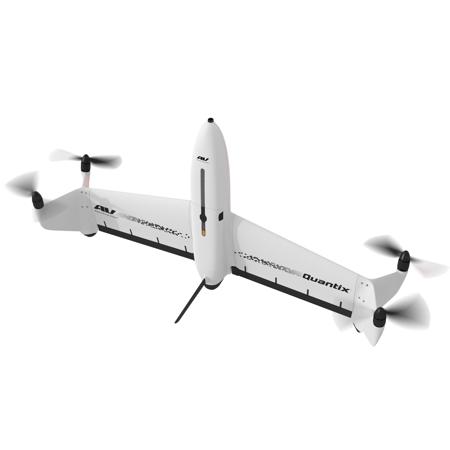
AeroVironment Quantix Mapper VTOL Hybrid UAV Drone System with Dual Cameras, Pix4d Fields Software, Lifetime License
SKU: AVQTIXFDSPRP
This item is no longer available.
Share:
Overview
Compare
Accessories
Specs
Protection

About AeroVironment Quantix Mapper
- Quantix Mapper -
AeroVironment is thrilled to announce our exclusive cooperation with Draganfly, Inc. to sell Quantix Mapper hybrid VTOL drone and Quantix-related parts & accessories.
Quantix is a powerfully simple to use UAV empowering users through its fully-automated operation and instant insight. Its hybrid design allows the aircraft to launch vertically and transition to horizontal flight; maximizing aerodynamic efficiency and range. Users can immediately view high resolution imagery on the included Operating Tablet - no other devices, internet or additional software required.
With the touch of a button, users can quickly and safely generate up to date maps for in-field assessment. Whether assessing crop growth during key stages, or damage from storm, flood and fire, Quantix Mapper makes It easy to gather accurate images across a large area, assess and react to situation with precision and speed.
Features
Quick-Look HD
Immediately see centimeter-level accuracy without any additional devices, internet, or software
High-Powered Cameras
Built-in dual 18MP cameras capture high-res RGB and multispectral images to provide 4x the coverage of most quadcopters
Non-Proprietary Image Formats
Data is available in open file formats for easy integration into a wide range of GIS, mapping, and 3d modeling tools
Camers
Simultaneously collects high-resolution RGB & Multispectral
Range (Liner)
2 km Radio Limit
Communication
900 MHz Encrypted & WiFi
Navigation
Fully Automatic Navigation
- Pix4Dfields Software -
Advanced agriculture mapping software for aerial crop analysis and digital farming
Capture
Collect images using a drone and any standard RGB or a selected multispectral camera like Parrot Sequoia+ and MicaSense RedEdge.
Use our Pix4Dcapture app to easily plan and control your drone flight for optimal mapping.
Process
Process imagery with the instant processing engine and get your maps directly in the field: 6.8 GB, 2948 images, 10 min (with the new radiometry module).
Scout
Generate precise orthomosaics, digital surface models, index maps, zones and accurate prescription maps.
Trim your fields to a desired field boundary to create more targeted outputs.
Analyze
Visualize and understand your crop growth stages and stress levels. Analyze and compare different layers of information for a full insight of your yield performance and use them to increase crop production and reduce costs.
Share
Share your maps with all project stakeholders for seamless collaboration using Pix4Dfields PDF report tool.
Integrate
Download all outputs, results and insights and import them into the Farming Management Software of your choice in various industry standard formats.
Precision agriculture mapping using images from drones and UAVs
The only digital agriculture software focusing on reducing the processing time while incorporating the highest accuracy standards backed up with years of scientific research.
In-Field Results
Create maps rapidly (no internet connection required) for faster decision making and action, without leaving the field.
Reliable Maps
Always get maps of your fields and crops at any critical stage regardless of satellite availability and cloud cover.
Trusted Results
Eliminate guesswork by analyzing crop health maps and measure issues using calibrated multispectral or full resolution RGB images.
Connected
Connect your data to platforms like the John Deere Operations Center, synchronize and access your data in-office and in-field for streamlined collaboration.
Use Pix4Dfields to create prescription maps and maximize crop yields
Create accurate field maps, generate insights and analyze field data in real time to increase crop productivity
Inspect, analyze and visualize your crop changes all year round
Fast mapping
Process imagery with the Pix4Dfields instant processing engine and achieve results in minutes in-office and in-field. No internet required.
Generate indices
Use the predefined list of agricultural indices or input your own custom index formula to understand your plant stress better.
Zonate and prescribe
Aggregate the information from the vegetation index maps into zones and assign application rates.
Compare
Link different layers of information and compare your crop trends over time in a split or a double screen.
Measure and Annotate
Add annotations to and measure important farm areas.
Export PDF report
Share your maps with all project stakeholders and team for seamless collaboration using Pix4Dfields PDF report tool.
Use aerial images to make the invisible, visible
Import images from any drone or UAV, captured with standard RGB or selected multispectral cameras
• Multispectral images
• RGB cameras, drone images
• Modified cameras
• Other cameras
Create and analyze real time maps of your crops to enhance your agriculture workflow
Easily scout your farm and generate the appropriate output for your needs
AeroVironment Quantix Mapper Features
- Fully Automatic - Safely collects hundreds of acres with simple user friendly inputs
- Quick-Look HD - Immediate access to georeferenced High-Resolution Images on tablet
- Adjustable Altitude - Simply change altitude to vary coverage rate and image resolution
- Non Proprietary images - Further analyze Quantix Mapper data with a wide range of tools