


+5
more
more
See Options
Need help? Ask our experts.
The following drone models may require a FAA Remote ID Module or Remote ID Device:
Mavic 2 Pro
Phantom 4 Pro
Mavic Air 2
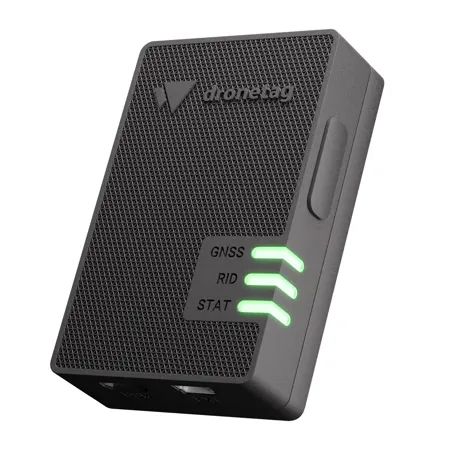
Professional Remote ID device attachable to any drone
Designed with expert pilots in mind. Combination of both Network & Direct / Broadcast Remote ID to make your drone flight safe & compliant.
Remote Identification
Network Remote Identification
Dronetag Mini transfers your drone's position and identification to our cloud. By displaying the real-time data in our app Dronetag enables advanced drone operations and coordination of manned and unmanned traffic in the same airspace.
Direct (Broadcast) Remote Identification
Your drone's info is transmitted via Bluetooth to up to 3 km (1.86 miles). With our Direct Remote ID, you fulfil all the new regulation necessities, and you are free to fly & touch the sky!
Smallest and lightest
Dronetag Mini is the smallest and lightest Remote ID device on the market. With the half size of a muesli bar, the weight of 32 g (1.1 oz), it offers everything you need to fly safe & compliant.
Independent, locked and with the longest battery life
Mini is attachable to any drone with a strong reclosable dual lock fastener (you can lift average drone by it). The device has internal GNSS, LTE and Bluetooth antennas and offers up to 14 hours of battery life.
Dronetag App - Available on all devices
Dronetag App allows you to manage your devices, check the airspace zones, plan your flights, inspect airborne drones & flight plans and notify you about any airspace hazards.
Pocket size technology
Compact but full of advanced technology
Weights only 32 grams and has half size of credit card
Features
Security at its best
Soldered chip SIM, firmware over the air updates, or DTLS encryption got you safe & secured.
Multi constellation GNSS receiver
Receiving signals from GPS, GLONASS, Galileo and SBAS for robust and reliable positioning.
Built according to the newest Remote ID standards
Compliant with Direct & Network Remote ID according to the prEN 4709-002 and ASTM F3411 Standards.
Internal LTE, Bluetooth and GNSS antennas
With an option to add external LTE and Bluetooth antennas for better signal reception.
Battery with up to 14 hours of endurance
You can also use your drone as a power source for carefree flights without the need for charging.
Take-off, landing and free-fall detection
Worry-free flight start and end. Mini warns other closed-by pilots about potential dangers.
Multiple sensors onboard
GNSS position estimation, pressure altitude measurement and motion detection via accelerometer.
MAVlink & DJI A3 support
Professional DJI and Pixhawk flight controllers integration via our EXT port to get onboard data.
Note: Firmware recovery dongle (do not use unless we specifically ask you to do so).
