About Skydio X10 VT300
- X10 Drone and Visible Light Navigation Camera -
You've never seen like this before
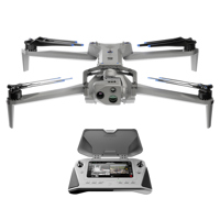
Skydio X10
The best sensors for a drone this small, piloted by the most advanced AI in the sky. To get the data you need, wherever and whenever you need it.
Visionary cameras to get the job done
Packing more megapixels and better optics than any drone its size, Skydio X10 boasts high resolution visual and radiometric cameras in modular sensor packages. So you can capture the right details for your job.
Unrivaled thermal imaging
Skydio X10 is the first drone ever to integrate a FLIR Boson+ sensor, delivering the highest quality thermal imaging. Capable of resolutions of 640 x 512 px and offering increased sensitivity down to <=30 mK, the X10 delivers more accurate radiometric readings, anytime, any place
Bring the sharpest details to every decision
Off-the-shelf components couldn't deliver the image quality our customers deserve. So, we engineered our own lenses. Achieve unrivaled resolution and superior focus with lenses you won't find anywhere else.
Pixel perfect images
Improve white balance, de-noise photos, extend HDR capabilities and more with sensors backed by the powerful Spectra 480 image signal processor.
Highest quality zoom
Maintain superior image quality even in zoomed-in shots through a compact transition zoom system.
Faster exposure times
Get outstanding images in lowlight, with custom wide aperture f/1.8 and f/2.2 lenses that allow 1.7-3.5x more light than competitors.
Onboard AI. Off-the-charts capability
Fly without limits or learning curves. With a drone that recognizes its surroundings, captures data automatically, and gets smarter over time.
Backed by an onboard NVIDIA Jetson Orin GPU, the X10 harnesses unrivaled computing power to make the right decisions in real-time. Six custom-designed navigation lenses provide 360-degree visibility, eliminating blind spots so you can fly fearlessly in any environment.
• 10X more computing power than the previous generation
• 10X more effective navigation pixels than the previous generation
• GPU Nvidia Onboard NVIDIA Jetson Orin GPU
Fly with ease
Navigate the most complex missions confidently, even in GPS-denied or high EMI environments. With superior AI flight assistance and obstacle avoidance, you no longer need to hire a specialist to get the job done, whether you're in the field with your drone, or piloting from a hundred miles away.
Automate complex missions
Complete targeted inspections automatically, with a new Spatial AI Engine that senses and understands what you're scanning. Efficiently build 2D maps and 3D models onboard, in real time. Or export data to Pix4D, Bentley iTwin Capture, DroneDeploy, or ESRI SiteScan.
Get smarter over time
Skydio X10 is loaded with the computing capacity for its AI data capture and synthesis capabilities to grow over time.
And do it all in the dark - Autonomous flight at night? You're not dreaming
Another industry first: Autonomy in the dark
Confidently operate 24/7 in NightSense mode for zero-light navigation - only available with the groundbreaking Skydio X10.
See in the dark
Skydio X10 uses visible or infrared illumination to avoid obstacles, understand its environment, and make the right decisions, every time.
IR Nav Cam and Illuminator
Using IR illumination, the X10 averts visibility at night.
Visible Light Nav Cam and Illuminator
Using visible illumination, the X10 provides bright 360 degree light.
Visible/IR light Module
Conduct autonomous flight in the dark with visible or infrared light.
Ultimate control becomes second nature - Fly however you want
Fly by controller
Plan, execute, and review any mission with the Skydio X10 Controller and Flight Deck, our optimized flight application.
Fly by browser
Launch and fly a drone from a browser with Skydio Remote Flight Deck, to get extra eyes on any situation.
Pass off piloting to a remote operator
Hand over control to an offsite pilot any time with Skydio Remote Flight Deck. The remote pilot can use a browser from any location to seamlessly pick up exactly where the onsite pilot initiated the handoff.
Fly wherever you need
Skydio Connect SL - Fly with a local connection
Fly up to 7.5 miles with Skydio Connect SL, the redesigned direct link from controller to drone. Our proprietary technology maintains a reliable connection in congested areas and enables piloting at distances beyond visual line of sight.
7.5 miles
Count on optimum robustness and range from the Skydio third-generation wireless link.
Skydio Connect 5G - Fly from your browser, with 5G
Get unlimited range wherever cellular coverage exists with Skydio Connect 5G. And now with Remote Flight Deck, you can pilot missions from anywhere on a browser.
Unlimited miles
Extend your range wherever there's a cellular connection.
Skydio Connect MH - Fly in contested environments
Perform with minimal interference in contested environments, with Skydio Connect MH. Global support across six frequency bands, in-flight channel selectability, and AES-256 encryption, enable reliable connectivity anywhere.
Always fly in compliance with the law and in accordance with Skydio Guidelines.
An operator experience forged by thousands of flying hours
Plan, execute, and review every type of mission on the redesigned Skydio Flight Deck app.
A pro-grade interface built from the ground up
Spend less time navigating menus to ensure faster operation during critical missions.
Do more with less distractions
Navigation camera view
See the 3D map the drone is creating in real time to fly with maximum confidence
Modify the interface to suit your needs
See more and do more, with swappable layouts and customizable telemetry
Always see what your drone sees
Maintain visibility of the drone's live preview, even while adjusting settings or receiving notifications
Quickly access key functions
Get immediate access to thermal settings, attachment actions, and AR overlays
See when conditions are changing
Receive notifications to keep track of fluctuating environmental conditions
Precision at your fingertips
Upgraded connectivity, customization options, and a rugged design lets you respond to any situation with total control.
Customizable controls
Get one-touch access to frequently used features.
Improved daytime visibility
With 60% increase in screen brightness.
Ruggedized hardware
IP54 weatherproofing protects from harsh conditions.
Robust connectivity
Supports Skydio Connect for low-latency control from anywhere.
Integrated apps. So work just flows
3D Scan
Create digital twins, indoors and out.
Remote Flight Deck
Fly remotely from a browser.
Onboard Modeling
Generate 2D/3D models in the field.
An open modular platform
With modular sensor packages and four attachment areas, the Skydio X10 swiftly adapts to changing mission requirements. Mount a parachute, microphone, spotlight and more, for a max payload of 12 oz.
Customize for your mission
Spotlight
Improve visibility during nighttime operations.
Speaker and Mic
Communicate and coordinate in high-risk situations.
Parachute
Designed to meet requirements for safe flying over people, provided by AVSS.
RTK GPS
Get exceptional accuracy for precision mapping and data collection.
NightSense Visible/IR light
Conduct autonomous flight in the dark.
Ready for anything, anytime, anywhere
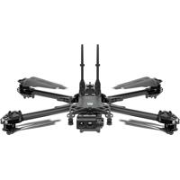
Designed from the ground up to bring the performance of a heavy drone to a backpack portable device. Weighing under 4.7 pounds with a 13.8 inch length, the Skydio X10 folds into the most compact size of any drone with similar sensors, truly enabling one-person operation.
Quiet propulsion
The efficient motors and folding 3-blade design of the Skydio X10 delivers a quiet flight profile while allowing for top speeds of up to 45 mph in stable air.
Lightweight materials
A lightweight and durable magnesium and carbon fiber frame, coupled with an innovative graphite heat-spreading system, ensures the Skydio X10 can withstand harsh environments to deliver vital aerial intelligence, anytime.
Withstand wind, rain, dust. And the unexpected.
Always in its element.
• Water and dust. Ingress protection: IP55 certified against dust, water and the unexpected
• Wind. Max gust handling: 28.6 mph / 43 kmh
• Cold and heat. Operational temperatures: -4 Degree to 113 Degree F / -20 Degree to 45 Degree C
• Altitude. Service ceiling: 15,000' (4.57 km)
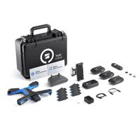
- VT300-L Sensor Package -
VT300-L provides a 64MP narrow module, a 1" wide module with a LED flashlight, and a FLIR Boson+ radiometric module. A great choice for mapping structures and inspections in low light environments.
FLIR Boson+ is a radiometric thermal module offered with the VT300-L sensor packages. This sensor is 40% more sensitive than its predecessor, the FLIR Boson 320x256, so Skydio X10 operators will be able to see much greater detail and get much more precise radiometric measurements than they ever have before.
Skydio X10 VT300 Features
- 45mph Max flight speed
- 40min Max flight time
- <40 sec Deployment time
- IP55 Certified against dust and water
Skydio X10 VT300 Specifications
DroneJump to...
- Startup Time
- Under 40 seconds
- Max Takeoff Weight
- 5.49 lbs (2.49kg)
- Operating Frequency
- Connect SL: 2400-2483.5MHz, 5150-5850Mhz
- Transmitter Power (EIRP)
- Connect SL: 34.3dBmi (2.4GHz)
Connect SL: 33.7dBmi (5GHz) - Hovering Accuracy (windless or breezy)
- VIO: +/- 10cm
GNSS: +/- 1m - Max Angular Velocity
- Yaw: 100 deg/s
Roll / Pitch: 225 deg/s - Max Tilt Angle
- 40 degrees
- Max Ascent/Decent Speed
- Ascent: 6 m/s / 13.4mph
Descent: 4 m/s / 9.0mph - Max Non-Vertical Descent Speed
- 6 m/s / 13.4mph
- Max Horizontal Speed (at sea level)
- 20 m/s / 45mph
- Max Horizontal Speed
- 16 m/s / 36mph (with Obstacle Avoidance)
- Max Service Ceiling Above Sea Level
- 15,000' density altitude (without other payload)
- Max Gust Handling
- 12.8 m/s / 28.6mph
- Max Hover Time
- 35 minutes
- Max Flight Time
- 40 minutes
- Processors
- NVIDIA Jetson Orin SoC
Qualcomm QRB5165 SoC - Ingress Protection Rating
- IP55
- GNSS
- GPS + Galileo + GLONASS + BeiDou
- Operational Temperature Range
- -4 Degree F to 113 Degree F (-20 Degree C to +45 Degree C)
- Wireless Range
- Connect SL: 7.5 miles (12km)
(no interference, line of sight operation) - Wireless Networking (media offload)
- Connect SL: Wi-Fi 6
- Obstacle Avoidance Coverage
- True 360 Degree
- Dimensions
- Unfolded, with propellers: 31.1 x 25.6 x 5.7" (78.99 x 65.02 x 14.47cm)
Folded, without battery: 13.8 x 6.5 x 4.7" (35.05 x 16.51 x 11.93cm) - Weight
- Connect SL with Batteries: 4.65 lbs (2.11kg)
ControllerJump to...
- Screen
- 6.6" (16.76cm) Dynamic AMOLED touchscreen
120Hz Adaptive Refresh Rate
Resolution: 2340 x 1080 pixels
Brightness: 1750 nits (outdoor peak)
392ppi - Max Range
- Connect SL: 12km / 7.5 miles
- Operating Frequency
- Connect SL: 2400-2483.5MHz, 5150-5850MHz
- Transmitter Power (EIRP)
- Connect SL: 34.7dBmi (2.4GHz)
Connect SL: 35.9dBmi (5GHz) - Ingress Protection Rating
- IP54
- Operating Time
- Approx. 5 hours
- Battery
- 9600mAH
- GNSS
- GPS + Galileo + GLONASS + BeiDou
- Operational Temperature Range
- -4 Degree F to 113 Degree F (-20 Degree C to 45 Degree C)
- Wired Outputs
- HDMI & USB-C
- Wireless Networking
- Wi-Fi, Cellular LTE/5G
- Security
- NDAA compliant
AES-256 encrypted data link
Encrypted internal disk storage
Password protected
Root of trust
Trusted boot
Secure update - Dimensions
- Controller: 10.5 x 5 x 3" (26.67 x 12.7 x 7.62cm)
- Weight
- 2.5 lbs (1.135kg)
VT300-L GimbalJump to...
- Angular Vibration Range
- +/-0.01 Degree
- User Controllable Range
- +/-90 Degree pitch
- Mechanical Range
- +/-140 Degree pitch, +/-90 Degree yaw, +75 Degree to -230 Degree roll
Wide CameraJump to...
- Sensor
- Sony IMX989 1" 50.3MP CMOS
- Diagonal Field of View
- 93 Degree
- Focal Length
- 8mm (20mm equivalent)
- Aperture
- f/1.95
- Focus
- 100% focus pixel, 1 m to Infinite
- Exposure Compensation
- +/-3
- Electronic Shutter Speed
- 1/30 to 1/8000
- ISO Range
- 100 to 16000
- Max Video Resolution
- 3840 x 2880
- Max Photo Size
- 8192 x 6144
Narrow CameraJump to...
- Sensor
- Sony 1/1.7" 64MP CMOS
- Diagonal Field of View
- 50 Degree
- Focal Length
- 10mm (46mm equivalent)
- Aperture
- f/1.8
- Focus
- hybrid PDAF, 1 m to Infinite
- Exposure Compensation
- +/-3
- Electronic Shutter Speed
- 1/30 to 1/8000
- ISO Range
- 100 to 16000
- Max Video Resolution
- 3840 x 2880
- Max Photo Size
- 9248 x 6944
Thermal CameraJump to...
- Thermal Imager
- Flir Boson+ Uncooled VOx Microbolometer
- Diagonal Field of View
- 41 Degree
- Focal Length
- 13.6mm (60mm equivalent)
- Aperture
- f/1.0
- Focus
- 5m to Infinite
- Thermal Sensitivity
- <30mK NEDT
- Infrared Temp. Measurement Accuracy
- Larger of +- 5 Degree C or 5%
- Image Processing
- Adreno 650 GPU accelerated ISP pipeline
- Max Video Resolution
- 640 x 512
- Photo Size
- 640 x 512
- Photo Format
- JPEG, RJPEG
- Pixel Pitch
- 12 um
- Temperature Measurement Method
- Spot Meter, Area Measurement
- Temperature Measurement Range
- -40 Degree to 302 Degree F (-40 Degree to 150 Degree C)
-40 Degree to 662 Degree F (-40 Degree to 350 Degree C low gain) - Palette
- White hot, black hot, ironbow, rainbow
Gimbal LightJump to...
- Illumination
- 1000 lumens
- Illumination (peak)
- 2800 lumens
- Configuration
- 6x cameras in trinocular configuration top and bottom
- Sensor
- Samsung 1/2.8" 32MP color CMOS
- Light Sensitivity
- Visible Light
- Aperture
- f/1.8
- Diagonal Field of View
- 200 Degree
- Obstacle Sensing Range
- 20m
- Environment Coverage
- True 360 Degree
Flight BatteryJump to...
- Capacity
- 8419 mAh
- Voltage
- 18.55 V
- Battery
- Rechargeable Lithium Ion Polymer
- Energy
- 156.17 Wh
- Operational Temperature Range
- -4 Degree F to 140 Degree F (-20 Degree C to 60 Degree C)
- Storage Temperature Range
- -4 Degree F to 113 Degree F (-20 Degree C to +45 Degree C) (storage less than 3 months)
- Charging Temperature Range
- 41 Degree F to 113 degree F (5 Degree C to 45 Degree C)
- Chemical System
- Lithium Ion Polymer
- Battery Info
- Required, included
- Battery Material
- Lithium ion
- Battery Type
- Non-universal
- Battery Quantity
- 3
- Weight
- 1.56 lbs (707.6g) (+/- 0.003 lbs)
Skydio ConnectJump to...
- Operating Frequency
- Connect SL: 2400-2483.5MHz, 5150-5850MHz
- Transmitter Power (EIRP)
- Connect SL: 34.7dBmi (2.4GHz)
Connect SL: 35.9dBmi (5GHz) - Antenna Configuration
- Connect SL: 2Tx, 4Rx
System SecurityJump to...
- Wireless Encryption
- Connect SL: AES-256
- NDAA Compliance
- NDAA Compliant
- Root of Trust
- HSM protected keys
- System Integrity
- Secure boot
- Secure Update
- AES-256 encrypted, signed, & verified
- Internal Disk Storage
- Encrypted
- SD Cards
- Unencrypted
- Pairing
- Secure wired pairing
Dual ChargerJump to...
- Charge Time 230W
- 1 hour 30 minutes (0-100%)
37 minutes (20-90%) - Charge Time 100W
- 1 hour 47 minutes (0-100%)
1 hour 12 minutes (20-90%) - Weatherproofing
- No ingress protection
- Dimensions
- 7.08 x 2.95 x 1.88" (180 x 75 x 48mm)
- Weight
- Without Battery: 11.68 oz (331.12g)
Product Comparisons
| Models |
Skydio Skydio X10 Drone Starter Kit w/Visible Light Camera & VT300-L SensorSKU: SKYD4ESKT1VL MFR: DR4ESKT1VLG0000NA
Temporarily On Backorder Free Shipping Although this item is temporarily on Backorder, you can order it now and it will ship as soon as it arrives. Your card will only be charged once item is shipped. |
Special Order Item Free Shipping This item is typically shipped to you directly from Manufacturer within 4-6 Weeks. Delivery is subject to availability. |
|
|---|---|---|---|
| Flight time (up To) | 40 min. | 35 min. | 27 min. |
| Camera Still Resolution | 0.3 MP, 50 MP, 64 MP | 12 MP | 12 MP |
| Gimbal Option | 3-Axis Gimbal | Flight Camera | 3-Axis Gimbal |
| FAA Registration (Non-Commercial Usage) | Over 250g (Required) | Over 250g (Required) | Over 250g (Required) |
| Camera Included | 4K Gimbal Camera, Built-in Camera, Thermal Camera | 4K Flight Camera, Built-in Camera, Thermal Camera | 4K Gimbal Camera |
| Drone Type | Quadcopters | Quadcopters | Quadcopters |
| Skill Level | Enterprise | Enterprise | Enterprise |
| Configuration | Drone with Camera | Drone with Camera | Drone with Camera |