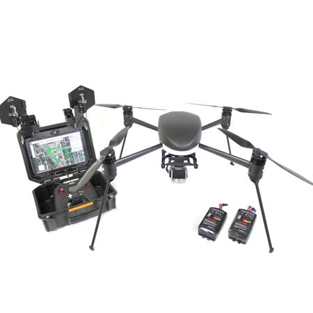
Draganfly Innovations Commander2 Ready to Fly System Mapping Package with RGB Mapping Camera System
SKU: DFCMDR2MAP
This item is no longer available.
Share:
Overview
Compare
Accessories
Specs
Protection

About Draganfly Innovations Commander2
Designed for mapping applications with high detail requirements, the Draganfyer Commander2 includes everything needed for flight and data collection. Flight execution and imagery capture is automated with the included flight management software which allows for flexible flight profiles including grid, perpendicular grid, cooridor mapping, and waypoint navigation. The Commander2 system is optimized for operation with Pix4d Mapper for postprocessing and creation of 3d models and orthomosaics. The 30 minute endurance allows for collection areas of up to 100 acres per flight while providing a real time video link to monitor you progress.
Draganfly Innovations Commander2 Features
- Designed, Manufactured, and Supported in North America
- Flexible mission planning and automated flight
- 2 axis stabilized gimbal with remote control of tilt
- Gimbal is stabilized on pitch and roll only to maintain NADIR orientation for mapping
- 24MP RGB sensor with Sony APS-C sensor
- 20mm E-mount interchangeable lens
- Automated data collection through DGroundControl
- Remote operation of shutter, and video recording