


See Options
Need help? Ask our experts.
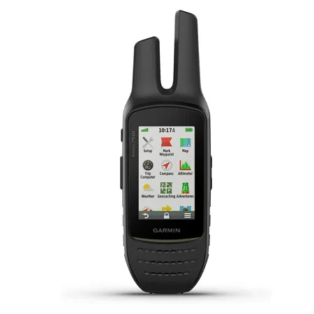
Before embarking on your next outdoor adventure, equip yourself with the Rino 750t 2-Way Radio/GPS Touchscreen Handheld Navigator. This rugged device combines the precision of GPS and GLONASS satellite reception with the convenience of two-way radio communication, offering a comprehensive solution for trail navigation and communication.
The Rino 750t is not just a handheld navigator; it's a communication hub. Its unique position reporting capabilities allow you to share your exact location with other Rino users, who can then view it on their map displays. The powerful 5-watt GMRS two-way radios facilitate easy voice communication with your group, while the unit-to-unit text messaging feature provides a nonverbal communication option.
The dual GPS and GLONASS satellite reception ensures that the Rino 750t can track and maintain your position, even in challenging environments like heavy cover, deep canyons, or remote locations. Share waypoints, tracks, routes, and geocaches wirelessly with other compatible Garmin handheld devices for seamless navigation.
The Rino 750t is equipped with a built-in barometric altimeter and 3-axis compass, making it easy to get your bearings. It supports advanced mapping capabilities and comes preloaded with TOPO 100K mapping for a detailed view of the terrain. The worldwide shaded relief basemap can be supplemented with a wide array of detailed topographic, marine, and road maps.
Stay ahead of the weather with active weather forecasts and animated radar tracking. When paired with a compatible smartphone and the Garmin Connect Mobile app, the Rino 750t provides real-time weather conditions, forecasts, and alerts. The built-in NOAA weather radio displays National Weather Service warnings and watches by county on the map screen.
Enhance your radio communications with Bluetooth connectivity by syncing your Rino 750t with a compatible headset. Receive smart notifications (calls, texts, emails, etc.) directly on your display when synced with a compatible smartphone. Customize your device's display with free downloads of apps, widgets, and data fields from the Connect IQ online store.
The Rino 750t is designed to withstand the elements. It's durable, water-rated to IPX7, and features a vivid, dual-orientation, 3" color touchscreen that's glove-friendly and easy to read in bright sunlight. A dual battery system allows you to use the included rechargeable lithium-ion power pack or an AA battery pack (sold separately), providing flexibility for extended use.
In summary, the Rino 750t 2-Way Radio/GPS Touchscreen Handheld Navigator with Sensors and TOPO Mapping is a robust, feature-rich device that enhances your outdoor experience by keeping you connected, informed, and on track.