Drones & Accessories
Save 5% Every Day† with the Adorama Edge Card. Learn More

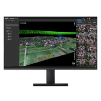
DroneSense Class 1 Dock Drone as First Responder Software License, Download
SKU: DSC1DKMFR: DSC1DK
Download Version
- Enhance drone operations with DroneSense software.
- Real-time data for DJI Matrice 3D/T Dock 2 systems.
- First Responder software license download included.
- Ensure flight stability with advanced DroneSense tech.
- Secure data via 4G/5G/LTE connectivity (min 5Mbps).
+ wishlist
Ways to Save

DJI Terra Standard with Modify Flagship 3D Modeling, Perpetual License, Online
SKU: DJICPRJ23201MFR: CP.RJ.00000232.01
- Streamlined drone flight planning software access.
- Accurate mapping capabilities for data analysis.
- Real-time feedback enhances drone operations.
- Seamless compatibility with DJI drones guaranteed.
- Simplified drone software ensures ease of use.
Special Order
?
Free Shipping

Skydio Cloud Enterprise for Real-Time Awareness, 1 Year Per Qty, Maximum 5 Years
SKU: SKYCLD102MFR: SKYCLD102
- Enhance operations with Skydio Cloud Enterprise.
- Real-time data streaming for superior awareness.
- Skydio Fleet Manager ensures efficient drone oversight.
- Streamline workflows with autonomous flight features.
- Secure data with 512GB storage & Skydio Media Sync.
Special Order
?
+ wishlist
Ways to Save

DJI FlightHub 2 Enterprise Version Package, 1-Year Subscription, 1-Device
SKU: DJICPRJ19201MFR: CP.RJ.00000192.01
Download Version
- DJI FlightHub 2 Enterprise: 1-Year Subscription.
- Comprehensive drone operation management software.
- Advanced flight planning for DJI drones.
- Streamlined data analysis and team collaboration.
- Robust monitoring for enhanced drone safety.

DroneSense Situational Awareness with TAK Geospatial Interface
SKU: DSINTTAKMFR: DSINT-TAK
Download Version
- Enhance drone operations with real-time data.
- Achieve mapping accuracy with DroneSense software.
- Ensure data security with advanced encryption tech.
- Experience automated flight for efficient missions.
- Maintain flight stability using DroneSense systems.
+ wishlist
Ways to Save

DJI FlightHub 2 Business Version Package, 1-Month Subscription
SKU: DJICPRJ25201MFR: CP.RJ.00000252.01
Download Version
- Streamline drone operations with powerful automation.
- Experience real-time drone data processing instantly.
- Ensure data accuracy with advanced drone software.
- Seamless drone compatibility and easy integration.
- Elevate customer support with advanced drone features.

DJI Terra Standard 3D Modeling and Mapping Software, 1 Year Subscription, Online
SKU: DJICPRJ23401MFR: CP.RJ.00000234.01
Download Version
- Precise drone mapping and analysis tools.
- Streamlined flight planning for DJI drones.
- Advanced data processing and analytics.
- Real-time feedback for enhanced control.
- Seamless compatibility across DJI platforms.

DJI Terra Standard 3D Modeling and Mapping Software, Perpetual License, Online
SKU: DJICPRJ22401MFR: CP.RJ.00000224.01
Download Version
- Streamline drone flight planning efficiently.
- Accurate 3D modeling for precise data analysis.
- Intuitive interface ensures ease of use.
- Advanced mapping capabilities, real-time tracking.
- Enhanced safety features for reliable operation.

DJI FlightHub 2 Mapping Recharge Package, 300000 Images, 1-Year Subscription
SKU: DJICPRJ19801MFR: CP.RJ.00000198.01
Download Version
- Access 300K images with FlightHub 2 annually.
- Optimize mapping with 1-year FlightHub 2 plan.
- Seamless DJI FlightHub 2 mapping compatibility.
- Enhanced performance for aerial mapping tasks.
- Unrivaled value in mapping image subscriptions.

DJI Terra Standard 3D Modeling and Mapping Software, Perpetual License, Offline
SKU: DJICPRJ21701MFR: CP.RJ.00000217.01
Download Version
- Offline processing for data accuracy.
- 3D modeling with perpetual license.
- Seamless drone software integration.
- Enhanced mapping capabilities included.
- Customizable missions supported.

DJI Terra 3D Modeling and Mapping Software for Education, Perpetual License, Online
SKU: DJICPRJ22601MFR: CP.RJ.00000226.01
Download Version
- Simplified drone flight planning and execution.
- Advanced 3D modeling for accurate mapping data.
- Robust data analysis for educational insights.
- Secure and real-time drone tracking included.
- User-friendly drone software for professionals.

DJI Terra Flagship 3D Modeling and Mapping Software, Perpetual License, Online
SKU: DJICPRJ22501MFR: CP.RJ.00000225.01
Download Version
- Advanced flight planning for drone mapping.
- Streamlined data analysis of drone imagery.
- Robust 3D modeling and mapping software.
- Real-time drone feedback for optimal flights.
- Perpetual license for enduring drone use.

DJI Modify Flagship 3D Model Editing Software, Perpetual License, Online
SKU: DJICPRJ23101MFR: CP.RJ.00000231.01
- Intuitive Ease of Use for 3D model editing.
- Precise Mapping analysis with flagship software.
- Streamlined drone flight modes optimization.
- Unrivaled 3D model data accuracy guaranteed.
- Perpetual software license, ongoing updates.
New Item
?
Free Shipping
Autel Mapper 2D/3D Reconstruction Software Perpetual Subscription
SKU: AR901030202MFR: 901030202
- Achieve centimeter-level mapping accuracy easily.
- Ensure data security with advanced encryption methods.
- Automate flight paths for efficient data collection.
- Process real-time data for immediate insights.
- Enjoy ease of use with intuitive software design.
Special Order
?
Free Shipping

AirData Enterprise with Livestream and Asset Management Starter Pack
SKU: ADAADENTCMFR: AD-ENT C
- AirData Enterprise: Streamline drone data analysis.
- Enhance flight stability with AirData's advanced tools.
- Real-time streaming for immediate aerial insights.
- GPS tracking ensures accurate drone location data.
- Manage drone assets efficiently with AirData software.
Ships from Manufacturer
?
Free Shipping

DJI Terra Flagship 3D Modeling and Mapping Software, 1 Year Subscription, Online
SKU: DJICPRJ23501MFR: CP.RJ.00000235.01
Download Version
- Precise 3D modeling for accurate data capturing.
- Streamlined flight planning for drone operations.
- Real-time mapping delivers instant visual data.
- Automated features enhance mapping workflows.
- Advanced post-processing optimizes aerial imagery.

Dronetag Unlimited Data Scanning Hours 1-Year Subscription Plan for RIDER
SKU: DTRIDERLCNC1MFR: DT-RIDER-LICENCE-1YEAR-UN
Download Version
- Unlock drone detection with Dronetag LTE.
- 1-Year Unlimited Data Scanning for RIDER.
- Unrestricted, nonstop performance. 12 mos.
- Full Dronetag Cloud visibility access.
- Enhance drone safety with new tech.

SkyeBrowse Dual Pilot Software, Annual License
SKU: SBDPILOTMFR: SBDP001
Download Version
- Enhance drone operations with SkyeBrowse software.
- Dual Pilot license ensures mapping accuracy annually.
- Real-time data processing for informed decisions now.
- Experience automated flight, simplified data security.
- Achieve flight stability with user-friendly software.
+ wishlist
Ways to Save

Phoenix LiDAR Spatial Explorer Perpetual
SKU: PHLSFTPCEXPPMFR: SFT.PC.EXP.P
Download Version
- LiDAR software ensures flight stability analysis.
- Process LiDAR data with ease of use interface.
- Analyze high-quality images with LiDAR software.
- Maximize drone range with optimized LiDAR data.
- Intelligent flight planning via LiDAR software.

SkyeBrowse Situational Awareness Package, Annual License
SKU: SBSITAWAREPKMFR: SB002
Download Version
- Real-time analysis for rapid situational awareness.
- Automated flight paths simplify data collection tasks.
- Process data quickly with SkyeBrowse software package.
- Ensure flight stability with advanced drone software.
- User-friendly interface for ease of use and training.
+ wishlist
Ways to Save
DJI FlightHub 2 Storage Space Upgrade Package
SKU: DJIFH2SSUPMFR: CP.RJ.00000104.01
- Enhance DJI FlightHub 2 with 500GB storage.
- Optimize drone software with expanded storage space.
- Ensure DJI FlightHub 2 compatibility, seamless use.
- Boost flight data storage for improved analysis.
- Upgrade drone software for enhanced data capacity.
Special Order
?
Free Shipping
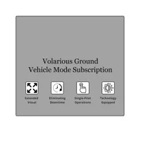
Volarious Ground Vehicle Mode Subscription for V-Line Pro M30
SKU: VLINEPROVMFR: VEHICLEMODE
- Enhance drone flight stability with Volarious software.
- Capture superior image quality using advanced algorithms.
- Experience ease of use with intuitive drone controls.
- Optimize battery life for extended drone operations.
- Unlock smart features for automated drone missions.
Special Order
?
Free Shipping
DJI Matrice 400 Drone, Bundle with Zenmuse L3 LiDAR Gimbal Camera
SKU: DJIM400CMFR: CB.202505213090 C
- Robust drone offers a superior 59-min flight time.
- Advanced LiDAR for precision obstacle avoidance.
- Extensive 40km flight range with secure GPS navigation.
- Capture sharp aerial 1080p drone footage expertly.
- All-weather IP55 portability ensures versatile drone use.
Temporarily On Backorder
?
Free Shipping


ACSL Inc. SOTEN Agriculture Bundle Plus
SKU: ACSSOTENBUNEMFR: SOTEN-MULTISPEC-BUN-PLUS
- 25-min flight time maximizes drone coverage.
- Integrated 4K drone camera captures crisp video.
- Rugged IP43 drone design ensures outdoor durability.
- Precision 3-axis gimbal enhances camera stability.
- Compact drone for easy portability and storage.
Temporarily On Backorder
?
Free Shipping


