This item is no longer available.
10 spectral bands for enhanced data comparison with satellites
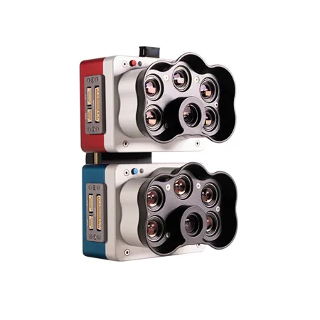
High-resolution multispectral and RGB composite drone sensor for vegetation analysis of water bodies, plants classification, weeds identification, environmental research and conservation. The dual solution features the RedEdge-P and the new RedEdge-P blue cameras. NDAA compliant.
Features
Double the analysis potential
Ten multispectral bands
The RedEdge-P dual bands cover Landsat 8 and Sentinel-2 satellite bands at an enhanced spatial resolution.
Panchromatic band for enhanced resolution
The RedEdge-P dual enables a GSD of 2cm per pixel / 0.8" per pixel when flying at 60m / 200'. Sharper imagery allows you to spot smaller problems sooner and make reliable decisions.
Coastal blue band
RedEdge-P dual unique coastal blue band is specially designed for water vegetation analysis and weeds identification in shallow water environments.
Narrow bands
Spectral narrow bands are key to detecting subtle variations in plant health and allow for more precise data. The RedEdge-P dual is a narrow-band sensor that captures the most relevant segments of the spectral curve.
Double calibration
The DLS light sensor and CRP reflectance panel are one of a kind in the market and allow accurate and reliable data in varying light conditions, enabling time series analysis.
Global shutter
On all 10 lenses that withstands vibration without degrading image quality. The global shutter of the RedEdge-P dual allows for distortion-free image captures.
Up to 3 images/second
CFexpress card of 128 GB storage enables up to three captures per second and immediate turnaround time between flights by swapping cards.
Synchronized capture
Synchronized capture of all 10-bands, automatic triggering and geotagging of images for efficient flight times and easy post-processing.
Two cameras, one workflow
Correlate drone and satellite data
The RedEdge-P dual bands cover Landsat 8 and Sentinel-2 satellite bands (-10 m / 32 ft per pixel) at an enhanced spatial resolution of 2 cm / 0.8". It enables the use of many indices already created using satellites.
Conduct time-series analysis
The RedEdge-P dual multispectral kit comes with a Calibrated Reflectance Panel (CRP) and a Downwelling Light Sensor (DLS). These radiometric calibration tools account for different weather and light conditions, providing data that enables reliable time series analysis and comparability of outputs over time.
Perform AI applications
The RedEdge-P dual's panchromatic band enables high-resolution RGB and multispectral imagery for machine learning applications, such as early-stage crop counting.
Compatible with a wide range of software
The RedEdge-P dual is compatible with the DJI Matrice 350 RTK and DeltaQuad Evo drones. The camera features an open API interface for easy integration with most flight planning and post-processing software.
Get insights invisible to the naked eye
Simultaneous capture of all bands, enabling multiple high-resolution outputs and indexes, such as RGB, NDVI, NDRE, OSAVI, NIT, CIR, DSM and more.
Made in USA
MicaSense series sensors are manufactured in the U.S. (NDAA compliant) and employed at academic, private and government institutions worldwide since 2014.
Use Cases and Applications
Perform detailed analysis
Vegetation analysis of water bodies
Surveys over water for chlorophyll efficiency examination, vegetation analysis and identification of algae or floating, submerged and emergent plants.
Environmental monitoring
Coastal and near-shore mapping for water resources management, tidal zones, swamps and glacier monitoring.
Water management
Public water supply surveillance, water resources management.
Habitat monitoring, protection and restoration
Erosion and biodiversity inspections, reef surveys over shallow waters, inaccessible to vessels and sensitive to human interaction.
Vegetation species and weeds identification
Vegetation health management and species identification, including the ability to differentiate and count plants, trees, invasive species, and weeds.
Radiometric calibration
DLS light sensor
The Downwelling Light Sensor (DLS) is an advanced incident light sensor. It measures the ambient light and sun angle for each of the multispectral bands of the camera. This information can then be used by specialized processing tools to correct global lighting changes in the middle of a flight, such as those that can happen due to clouds covering the sun.
CRP reflectance panel
The Calibrated Reflectance Panel (CRP) is a compact radiometric calibration tool. The panel has pre-measured reflectance values across the visible and near-infrared light spectrum and therefore acts as a "control". Taking a picture of the calibration panel allows you to assign the known reflectance values and adjust your dataset accordingly during post-processing.