


Need help? Ask our experts.
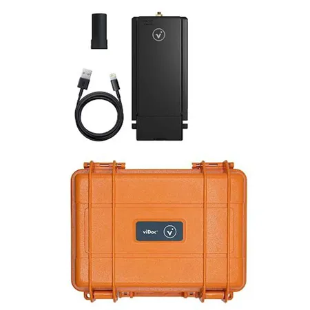
An innovative solution for professional surveying and 3D scanning, the viDoc RTK Rover revolutionizes the way you capture and document spaces. This high-quality rover is designed to work seamlessly with selected iPhone and Android devices, offering a future-forward approach to single point measurement and 3D scanning.
Harness the power of the viDoc RTK Rover to document trenches with PIX4Dcatch, a cutting-edge application that enables you to digitize and document trenches and as-built objects on construction sites. This handheld RTK rover elevates single point measurement with 3D scans, offering multiple options for accurate point measurement. Whether you're using the laser, photogrammetry, or attaching it to a surveying rod, you can measure obstructed points and complete data collection without missing anything that may be obstructed by objects like trees or overhangs.
The viDoc RTK Rover ensures accurate and safe measurement methods, helping you reduce risks and unnecessary site visits, making data collection safer and more efficient. Paired with the PIX4Dcatch, this RTK positioning rover enables real-time geotagging of 3D scan images using NTRIP services, enhancing your mobile data collection process.
With the ability to connect to over 600 channels, including all major constellations such as GPS, GLONASS, Galileo, etc., the viDoc RTK Rover ensures rapid convergence in under 5 seconds. This innovative tool replaces complex workflows, offering a more convenient alternative to bulky and expensive ground surveying equipment like laser scanners.
The viDoc RTK Rover, in conjunction with an iOS device, PIX4Dcatch, and PIX4Dcloud, provides an end-to-end solution that delivers measurements with an absolute accuracy of less than 5cm. Its intuitive design and structure make it easy for anyone to collect points or complete an accurate 3D scan.
Designed specifically for devices equipped with LiDAR sensors, the viDoc RTK Rover for PIX4Dcatch is perfect for accurately capturing 3D spaces from the ground. It works with selected models, including Android devices. Experience the convenience, accuracy, and efficiency of a complete workflow in your hands with the durable and stylish viDoc RTK Rover.
Not sure which phone/tablet case you need for the viDoc RTK Rover
See this link for the supported phones: https://support.pix4d.com/hc/en-us/articles/360043331092