
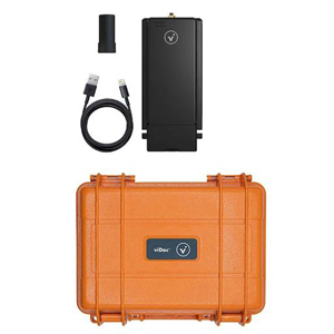
Pix4D Incident Management Hardware Bundle with viDoc RTK Rover for Smartphone, Perpetual License
SKU: P4DIMHB
This item is no longer available.
Recommended Alternatives
Share:
Overview
Compare
Specs
Protection
About Pix4D viDoc RTK Rover w/viDoc
Perpetual license for the ultimate incident management hardware bundle.
The hardware bundle for professionals in public safety. Get centimeter accurate terrestrial scans with the viDoc, and process results with PIX4Dmatic or PIX4Dmapper. Use iOS LiDAR data and merge it with photogrammetry datasets to recreate accident scenes with accuracy. Use your results as part of investigations, trusting your outputs can be used in court. Fast-mapping with PIX4Dreact, large scale mapping with PIX4Dmatic, and comprehensive 3D reconstructions with PIX4Dmapper, alongside the terrestrial site scanning tool viDoc. Have it all with this bundle.
- viDoc RTK rover -
For selected iPhone and Android devices.
The future of single point measurement with 3D scanning
Use a handheld RTK rover to elevate single point measurement with 3D scans
Multiple options for accurate point measurement
Measure with the laser, photogrammetry, or attach it to a surveying rod.
Measure obstructed points
Complete data collection without missing anything that may be obstructed by objects like trees or overhangs.
Accurate and safe measurement methods
Get your measurements and reduce risks - cut unnecessary trench visits, etc. Make data collection safer.
The viDoc RTK rover with PIX4Dcatch
Accurate surveying with a mobile device
Easy field-to-finish workflows
Easy digitalization with Pix4D software that can measure single points or create line work from data capture.
RTK positioning rover for 3D scanning
viDoc RTK rover pairs with the PIX4Dcatch to geotag images of the 3D scan in real-time using NTRIP services.
Enhanced mobile data collection
viDoc connects to over 600 channels (including all major constellations such as GPS, GLONASS, Galileo, etc.) which results in convergence in under 5 seconds.
Replacing complex workflows
Ground surveying equipment like laser scanners can be expensive, bulky, and highly technical. Drones can be restricted by regulations. Overcome the obstacles with a handheld rover.
A complete, accurate workflow in your hands
The viDoc, the smartphone, PIX4Dcatch, and PIX4Dcloud. An end-to-end solution that gets measurements at centimeter level absolute accuracy.
Intuitive feel and structure
Easy for anyone to collect points or complete an accurate 3D scan. The handheld rover combines with mobile software to create digital twins as fast as possible.
- PIX4Dmapper -
The leading photogrammetry software for professional drone mapping
Capture
Capture RGB, thermal, or multispectral images with any camera or drone and import them to PIX4Dmapper.
Digitize
PIX4Dmapper's photogrammetry algorithms transform your ground or aerial images in digital maps and 3D models. Seamlessly process your projects on your desktop using our photogrammetry software, or bundle with PIX4Dcloud for online processing.
Control
Use the power of photogrammetry in the rayCloud environment to assess, control and improve the quality of your projects. Use the quality report to examine a preview of the generated results, calibration details, and many more project quality indicators.
Measure & inspect
Accurately measure distances, areas, and volumes.
Collaborate & share
Streamline project communication and teamwork. Selectively and securely share project data and insights, with your team, clients, and suppliers, using standard file formats.
Photogrammetry solution to power applications across industries
Advanced data processing for precise results
Survey-grade results
• Obtain results with sub-centimeter accuracy thanks to photogrammetric analysis
• 1-2 pixel GSD in X, Y directions
• 1-3 pixels GSD in the Z direction
Complete control over your project
Define an area of interest, select processing options, add ground control points or edit point clouds, DSMs, meshes, and orthomosaics.
Your workflow, your choice
Use default templates for automatic processing of your projects, or create your own with custom settings for full control over the data and quality.
rayCloud - The power of photogrammetry software
A unique environment connecting your original images to each point of the 3D reconstruction to visually verify and improve the accuracy of your project
The end-to-end photogrammetry tool for every project
Accurate 3D maps and models, purely from images
Automatic point cloud classification
Distinguish objects with machine learning classification processes.
Flatten & smoothen digital surfaces
Create surfaces to improve planarity or fill holes in critical areas.
Easily measure surface, distance & volume
Measure in 3D with a fully-adjustable base height.
Control over the project accuracy
Annotate and edit 2D and 3D GCPs, check points, and MTPs with the highest accuracy, using both original images and 3D information at the same time.
Detailed quality report
Assess the accuracy and quality of your projects.
- PIX4Dreact -
2D fast-mapping for emergency response and public safety
Capture
Fly your drone to capture the images you need. Plan an optimized and automated flight with an app like PIX4Dcapture for Parrot and DJI drones.
Process
Combine large numbers of images in minutes with PIX4Dreact. Create measurable 2D maps in the field or back at base.
Examine
With PIX4Dreact's simple tools, identify and measure points of interest, mark and evaluate your maps while on the ground to provide powerful data needed to take action.
Share
Export your maps to ensure teams and decision makers are provided with effective information when it's needed most.
Respond
With up-to-date maps, gain precious time, improve safety and reduce costs when responding to an evolving situation.
The mapping software for emergency response
Get rapid and reliable situational awareness for quick decisions and collaboration in the field.
Fast
PIX4Dreact creates 2D maps from aerial imagery in minutes. Because when every second counts, up-to-date and reliable information is of utmost importance to teams on the ground.
Easy to use
Simple and intuitive to use, even in complex and stressful situations. PIX4Dreact is developed with public safety and humanitarian aid professionals to meet their unique challenges.
Lightweight and robust
Lightweight enough to work on a mid-range computer in the field. PIX4Dreact doesn't rely on an internet connection or the cloud for processing.
Share findings
PIX4Dreact outputs can be uploaded to PIX4Dcloud for sharing. Export your maps and reports and seamlessly send them to colleagues or teams on the ground.
Reliable situational awareness in complex situations
Fast and intuitive mapping
Get a fast aerial overview of the scene in minutes without internet. Overlay the US national grid to your maps to make them universally understood.
Measure and mark areas of interest
Connect your maps with what you see on the ground. Rely on powerful rapid insights directly from the field and easily mark and measure points of interest.
Fast and easy export
Share 2D orthomosaic maps and annotations as a PDF report which are lightweight enough to send over email.
Share to PIX4Dcloud
Upload PIX4Dreact outputs (orthomosaic, surface model) directly to PIX4Dcloud for sharing
Fit for purpose
Use PIX4Dreact as a stand-alone 2D fast-mapping software, tailor-made for emergency response or together with PIX4Dmapper for extra analytical functionality.
- PIX4Dmatic -
Next-generation photogrammetry software for terrestrial, corridor and large scale mapping
Are you ready to go big
The optimized software for the next surveying and mapping challenges
Bigger datasets, accurate results
PIX4Dmatic processes thousands of images while maintaining survey-grade accuracy, halving the processing time, without the trouble of splitting and merging.
Fully automated processing
Developed in close-collaboration with surveyors and mapping professionals to streamline your workflow: import, process and assess the quality of a project in just a few clicks, and move seamlessly from PIX4Dmatic to PIX4Dsurvey.
Terrestrial workflow
Leverage the benefits of both photogrammetry and LiDAR technology. Process LiDAR and RGB image outputs from PIX4Dcatch for a full terrestrial workflow. Easy and desktop-based.
Accurate 3D maps and models from thousands of images
Fast processing
Handling and processing large amounts of data is easy with PIX4Dmatic. Get your results up to 50% faster, while keeping a survey-grade accuracy.
Easy accuracy checks
Ensure the accuracy of your project with GCPs, Checkpoints, or Manual Tie Points. Accuracy metrics are available in a dedicated tie points table and in an exportable quality report.
Vertical coordinate systems and geoid support
PIX4Dmatic supports the most frequently used vertical coordinate systems and their corresponding geoids.
Import from PIX4Dcatch
Process both LiDAR and RGB image outputs from PIX4Dcatch.
Fast development cycles
Updates are released every three weeks in a new preview or stable version, ensuring you get all the latest improvements and features.
Pix4D viDoc RTK Rover w/viDoc Features
- viDoc RTK rover Features
- Use a handheld RTK rover to elevate single point measurement with 3D scans
- Multiple options for accurate point measurement
- Measure obstructed points
- Accurate and safe measurement methods
- Pix4Dmapper Features
- Automatic point cloud classification
- Flatten & smoothen digital surfaces
- Easily measure surface, distance & volume
- Control over the project accuracy
- Detailed quality report
- Pix4Dreact Features
- Fast and intuitive mapping
- Measure and mark areas of interest
- Fast and easy export
- Share to PIX4Dcloud
- Fit for purpose
- PIX4Dmatic Features
- Fast processing
- Easy accuracy checks
- Vertical coordinate systems and geoid support
- Import from PIX4Dcatch
- Fast development cycles