This item is no longer available.
Parrot Bluegrass Fields
The End-to-End Drone Solution for Agriculture
Parrot Bluegrass Fields is a comprehensive, ready-to-fly drone solution that spans the entire crop analysis workflow. Parrot Bluegrass Fields provides agriculture professionals with the insights they need to maximise their yields and boost the quality of their crops.
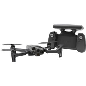
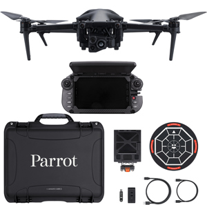
• The rugged, easy-to-fly Parrot Bluegrass drone
• The industry-leading Parrot Sequoia multispectral sensor and a 14 MP front RGB camera
• ParrotFields mobile app to simplify the entire in-field workflow (one-year subscription)
• A full access to Pix4Dfields desktop and cloud software for further in-depth analysis of crop data gathered (one-year subscription)
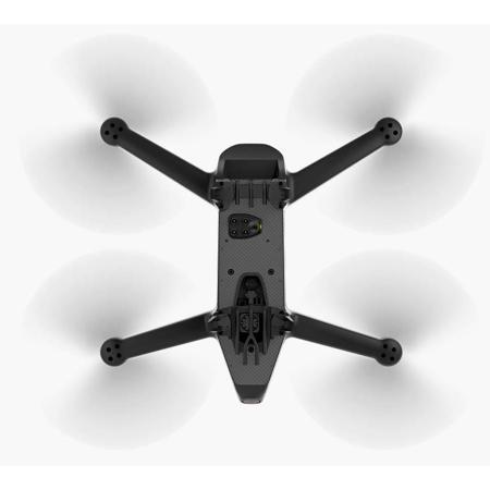
Efficient, Rugged & East-To-Fly Quadcopter Drone
Parrot Bluegrass Fields is a rugged and easy-to-fly quadcopter drone designed for both crop mapping and aerial scouting.
• Cover large fields up to 65 ha (160 ac) at 122 m (400 ft) or fly low for greater resolution of down to 0.9 cm/px at 10 m (0.35 in/px at 33 ft) - single image
• Flexbile vertical take-off and landing (VTOL) capability ensures efficient operation, even in confined areas
• Three included batteries (25-minute flight time per battery) let you fly longer missions with greater ease and confidence
• Make short work of demanding environments with Parrot Bluegrass Field's robust, professional-grade carbon-fibre structure
• Intuitive Parrot Skycontroller 2 suits every pilot's needs
Versatile Visual Scouting & Crop Mapping
Equipped with two integrated multipurpose sensors, Parrot Bluegrass Fields is the perfect professional drone solution for visual scouting and crop mapping.
• An industry-leading multispectral Parrot Sequoia sensor allows for highly accurate crop mapping
• Four multispectral mono-bands (Red, Green, RedEdge, Near Infrared), 1.2 MP, global shutter
• Multispectral GSD of 11.5 cm/px (4.5 in/px) at 122 m (400ft) flight height (or 2.8 cm/px (0.8 in/px) at 30 m / 100 ft)
• Front 14 MP RGB Camera for fast and effective live scouting of problem areas, including the capture of photos and Full HD-quality video at 1080p
Actionable In-Field Insights With Parrotfields Mobile App
Parrot Bluegrass Fields makes mapping and scouting quick and simple.
• Perform fully automatic flights or fly manually over your crops
• Generate NDVI maps in real-time during flight
•Get the data you need faster. Compare NDVI maps to monitor the evolution of your crops from the convenience of your mobile device
•Explore areas of interest via Parrot Bluegrass Fields' unique semi-automated scouting flights
•Capture photos and videos on-demand with the Parrot Skycontroller 2
•Increase the value of the aerial data you capture by adding text annotations within the app and from the ground with the added benefit of taking GPS-tagged picture
In-Depth Crop Analysis With Pix4dfields
Parrot Bluegrass Fields help you make smarter decisions with greater analysis by providing full access to Pix4DFields drone mapping software for agriculture.
• Identify in-field variability faster with the new instant processing engine (process 50 ha / 123 ac in 1.5 minutes)
• Generate predefined or custom index maps for detailed crop performance analysis
• Visualize and understand crop trends by comparing different data layers side by side
• Create comprehensive zonation and prescription maps for more precise fertilizer applications
• Import or draw field boundaries and annotate crop 'focus areas' for a more in-depth inspection
• Export prescription maps to your tractor or Farm Management Information System for seamless integration into existing agriculture workflows
Parrot Bluegrass Fields: The Better Way To Work In-Field
Parrot Bluegass Fields provides agriculture professionals with a better way to work, thanks to its unique combination of rugged drone, accurate sensors, easy-to-use mapping and scouting ParrotFields app and robust post-processing software for agriculture. Parrot Bluegrass Fields is the only complete end-to-end drone solution designed from the ground up to make data collection and analysis quick, easy and efficient.
Step 1.In-Field Set-Up
.Parrot Bluegrass Fields is easy to transport and set-up. Carry your Parrot Bluegrass Fields drone in its tailor-made backpack, which conveniently houses three batteries that provide 25 minutes of flight time each, to your desired location. From there, simply connect your smart device to the included Parrot Skycontroller 2, prepare your first automatic flight via the ParrotFields mobile app and you're ready to start mapping.
Step 2. First Flight For Crop Mapping
Parrot Bluegrass Fields makes it easy to map multiple fields and generate NDVI crop maps. Just plan your flight using the ParrotFields mobile app and the drone will fly above your field, automatically map the area and create an NDVI map in real-time.
With Parrot Bluegrass Fields, you can fly high to cover larger areas or fly low for better resolution, depending on your project's requirements.
Step 3. In-Field Analysis
Using the NDVI map processed in real-time, it's easy to instantly analyse and compare crop data, including any potential problem areas. You can even compare current NDVI maps with past versions to track the evolution of your crops or add value to your map by adding text annotations.
Step 4. Follow-Up Flight For Aerial Visual Scouting
After identifying problem areas, you can perform a semi-automated follow-up flight using ParrotFields on any areas that require further analysis. Simply program a second flight based on the NDVI map result and the drone will automatically fly from one identified problem area to another. You can then take manual control of the drone, inspect each area with the front RGB camera (14 MP), take pictures of the video feed with the single push of a button on your Parrot Skycontroller 2 and get a better understanding of any potential problems affecting your crops.
Step 5. Ground Scouting
ParrotFields also allows you to complete aerial data with ground data. After flying over potential problem areas, operators can walk their fields and take pictures directly using the ParrotFields app. These images are GPS-tagged and can receive additional text annotations for easy reference.
Step 6. In-Depth Analysis
Whether through the cloud or their desktop computer, Parrot Bluegrass Fields solution lets operators further analyse the data collected through the included Pix4Dfields software.
With Pix4Dfields, you can identify in-field variability, generate index maps, create prescription maps and much more.
Step 7. Seamless Workflow Integration
Parrot Bluegrass Fields solution seamlessly integrates into existing workflows. Pix4Dfields outputs can be integrated into almost any FMIS, and directly into tractors, which can then be utilised efficiently in the field and help farmers to know exactly where and how much to fertilise their crops.