+6
more
more
This item is no longer available.
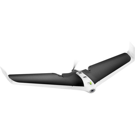
Parrot Disco-Pro AG is the all-in-one multipurpose drone solution for farmers that fits in their tool box to help them improve the ROI of their crops. This end to end solution allows farmers and small agriculture cooperatives to quickly get an insight on the health of their crops, thanks to visual crop scouting and specialized NDVI maps.
Easy To Pilot And Reliable Drone Solution
With its enhanced aerodynamic design and its advanced autopilot, Parrot Disco-Pro AG is easy to pilot, reliable and safe. This fixed wing drone solution comes with a powerful motor and a high capacity battery that covers up to 80ha / 200ac at 120m / 400ft flight altitude in a single flight. The new Parrot Skycontroller 2 ensures an optimized and secure Wi-Fi connection and live video streaming on your smartphone via the FreeFlight Pro app.
Capture Crop Data With Parrot Sequoia
Parrot Sequoia is a cutting-edge multispectral sensor for precision agriculture. With its two sensors, multi-spectral and sunshine, Parrot Sequoia analyses plants' vitality by capturing the amount of light they absorb and reflect. When facing downwards, the high precision multispectral sensor captures RGB photos and the light plants reflect in four separate bands: green and red lights and two infrared bands invisible to the human eye. When placed on the drone facing up, the sunshine sensor records the intensity of light emanating from the sun, so you can perform radiometric calibration to ensure consistent data measurement.
Analyze Your Crops With Airinov First + NDVI Maps
AIRINOV First + is the powerful and easy-to-use agricultural cloud mapping platform that processes captured crop data into actionable insights. All it takes is 3 simple steps; create your account, upload your photos to the cloud and generate your actionable AIRINOV report.
The AIRINOV report gives you insights on your crops by processing up to 150ha / 370 acres per week and includes
• NDVI maps: the easiest way to measure intra-field variability
• Simple zoning map for a quick analysis
• Detailed zoning map to help estimate Variable Rate Application
This Solution Meets The Following Needs
Inspection And Analysis of Major Crops
Optimizing Choices And Movements For Better Crop Health. Thanks to its turnkey solution, Parrot allows farmers to monitor their crops from the air by conducting drone flights that require no knowledge of flying. Equipped with state-of-the-art technology, the farmer can easily control his device to analyse up to 150 ha of data per week via NDVI maps and generated zonings. Radiography of unprecedented precision to draw up an inventory of the various plots of land.