

Need help? Ask our experts.
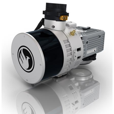
Before you delve into the world of advanced technology, consider the high-tech and sophisticated Recon-XT Payload Package by Phoenix Lidar. This innovative system is the ultimate solution for users seeking an entry-level system compatible with the DJI Matrice 300. It's an ideal choice for teams working with smaller scan areas or those operating on a budget.
The Recon-XT is more than just a powerful tool; it's a flexible system designed to evolve with your business. Its versatility extends to its mounting options, making it a key asset for any Phoenix system. Primarily designed to fly on the DJI M300, the Recon-XT can also be adapted for vehicle and backpack configurations, demonstrating its adaptability.
As a complete LiDAR solution, the Recon-XT meets the growing demands of various industries, ranging from mining and agriculture to construction and forestry. It offers survey-grade accuracy with a 130m laser range and the ability to penetrate vegetation for precise results.
The Recon-XT comes with a host of features, including free online tutorials and optional acquisition, post-processing, pilot, and certification training. It also includes a PC Master Suite, with NovAtel and Terrasolid options available. For those seeking to expand their capabilities, optional upgrades such as ground vehicle and UAV mounts/accessories, service plans, and more are available.
The Recon-XT also includes an external USB storage with 256GB of space, perfect for capturing data throughout the day. Its primary applications extend to vegetation penetration, utility infrastructure, open pit mining, forestry, construction site monitoring, cultural preservation, glacier and snowfield mapping, and land erosion.
The Recon-XT is now integrated with LiDARMill, a complete cloud software suite that adds geo-referencing, data-fusion, post-processing, export, hosting, and sharing capabilities, all in the cloud.
Phoenix Lidar Systems also introduces the new PLS Care Service Program, an annual service offering unlimited support on the RECON Series. This program provides extended warranty options, full access to training video series, supporting documentation, and the Phoenix Flight Planner tool. Phoenix is committed to the success of its customers and the PLS Care program is designed to provide long-term support for the products and their users.