Picture does not represent the actual item
See what's in the box
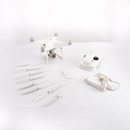
Picture does not represent the actual item
See what's in the box
This item is no longer available.
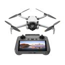
Plant Intelligence for Targeted Action
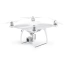
Gather precise plant-level data using the P4 Multispectral - a high-precision drone with a seamlessly integrated multispectral imaging system built for agriculture missions, environmental monitoring, and more.
Farm to Figures
Gain Immediate Insights into Plant Health
The P4 Multispectral consolidates the process of capturing data that gives insight into crop health and vegetation management. DJI has created this platform with the same powerful performance standards that DJI is known for, including 27 minutes max flight time and up to 7 km transmission range with the OcuSync system.
See Beneath the Surface
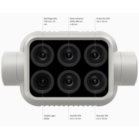
Agriculture imagery collection is now simpler and more efficient than ever before with a built-in stabilized imaging system that collects comprehensive data sets right out of the box. Access information collected by 1 RGB camera and a multispectral camera array with 5 cameras covering Blue, Green, Red, Red Edge, and Near Infrared bands - all at 2 MP with global shutter, on a 3-axis stabilized gimbal.
Integrated Spectral Sunlight Sensor for Accurate Results
An integrated spectral sunlight sensor on top of the drone captures solar irradiance, which maximizes accuracy and consistency of data collection through different times of day. When combined with post-processed data, this information helps to obtain the most accurate NDVI results.
Meaningful Data at Your Disposal
View Both RGB and NDVI Feeds
Simply having aerial imagery is not enough for ag professionals who want to know more. Switch between a preliminary Normalized Difference Vegetation Index (NDVI) analysis and the live RGB feed to immediately visualize where attention is needed, so targeted treatment decisions can be made quickly.
Centimeter-level Precision
Get real-time, accurate positioning data on images captured by all six cameras with DJI's TimeSync system, providing centimeter-level accurate measurements. The TimeSync system continually aligns the flight controller, RGB and NB cameras, and RTK module, fixing the positioning data to the center of the CMOS and ensuring each photo uses the most accurate metadata. All cameras go through a rigorous calibration process where radial and tangential lens distortions are measured. The distortion parameters gathered are saved into each image's metadata, letting post-processing software adjust uniquely for every user.
D-RTK 2 Mobile Station and NTRIP Compatibility
Enhance the accuracy of RTK positioning without internet connection by connecting the P4 Multispectral to the D-RTK 2 High Precision GNSS Mobile Station and NTRIP (Network Transport of RTCM via Internet Protocol), or store the satellite observation data to be used for Post Processed Kinematics (PPK).
The Beginning of Intelligent Agriculture Missions
Plan Flights
Plan flights, execute automated missions, and manage flight data using GS PRO - DJI's leading flight planning iOS app.
Capture Data
Collect multispectral images efficiently across a large area using the P4 Multispectral and gain an overview of problem areas.
Analyze Data
Easily access and process aerial data by applying plant-specific metrics and parameters to acquire the desired results on plant health.
Act on Data
Implement targeted treatments on areas that need attention based on accurate drone data.
Applications
Precision agriculture
Throughout all growing seasons, multispectral imagery can be helpful to ag professionals by providing information invisible to the human eye across the electromagnetic spectrum. Having access to this data and the subsequently obtained Vegetation Index data such as NDRE and NDVI, farmers can make timely, informed decisions on crop treatment, lowering costs, saving resources, and maximizing yields.
Environmental monitoring and inspection
Routine inspections and maintenance involving plants can be made smarter and more efficient when using the P4 Multispectral - leverage its actionable multispectral insights to monitor forest health, measure biomass, map shorelines, or manage riparian vegetation while protecting habitats or ecosystems, and much more.