Share:
$227 PRICE DROP
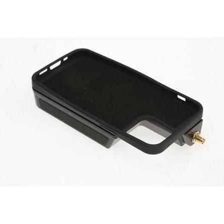
Used Condition: Open Box Used Pix4D viDoc RTK Rover for iPhone 12 Pro Max
SKU: US1568450 MFR: 3240.02
Earn VIP Reward PointsWhat`s in the box:
- Pix4D viDoc RTK Rover
- USB Charging Cable
- GNSS Antenna
See more
Key Features
- Ground Photogrammetry Reinvented
- Accuracy at Your Finger Tips
- Affordable
- Intuitive
- RTK Positioning Rover for 3D Scanning
- Enhanced Performance
INCLUDES FREE WARRANTY
- This used item comes with a free 1-year warranty. ?
Need help? Ask our experts.
Overview
Compare
Specs
Protection
About Pix4D viDoc RTK Rover for iPhone 12 Pro Max
The viDoc RTK rover is a device that can be mounted onto Apple iPhone 12 Pro Max. The rover, synchronized with PIX4Dcatch, geotags images with RTK accuracy in real-time, while connected to any NTRIP service, allowing absolute accuracy in 3D photogrammetric scanning.
viDoc RTK Rover for PIX4Dcatch
Elevate 3D scanning with the power of RTK and photogrammetry on a mobile device
Capture
Couple the viDoc RTK rover to PIX4Dcatch via Bluetooth and connect to any NTRIP service of your choice.
Walk around your area of interest to acquire high-precision positional data for individual images.
Upload
Stop recording and automatically upload the captured images to PIX4Dcloud to generate accurate and easy-to-share 3D models.
Examine
Measure distances, areas, and volumes around the model and perform virtual inspections.
Share
Selectively and securely share project data and insights with your team, clients, and suppliers.
Ground Photogrammetry Reinvented
Surveying just got simpler, safer, and more efficient than ever.
Accuracy at Your Finger Tips
The viDoc RTK rover combined with an iPad Pro/iPhone 12, PIX4Dcatch and PIX4Dcloud is the new generation of work-site ground surveys, allowing for measurements with an absolute accuracy within 5 cm.
Affordable
Get RTK accuracy without a mobile station, for a fraction of the time and price. Unlock powerful, precise results with just a handheld iOS device.
Intuitive
Easy for anyone to perform ground-based 3D modeling with a high degree of accuracy. The handheld viDoc RTK rover combined with the intuitive PIX4Dcatch app makes the creation of digital twins easier and faster.
The viDoc RTK rover for PIX4Dcatch: Accurate Surveying with a Mobile Device
German-made
Conceived by vigram GmbH., a German company led by professional surveyors.
RTK Positioning Rover for 3D Scanning
The viDoc RTK rover, synchronized with PIX4Dcatch, geotags the images of the 3D scan in real-time, while connected to any NTRIP service.
Enhanced Performance
The viDoc RTK rover supports 600 channels including all major constellations (GPS, GLONASS, Galileo and BeiDou) resulting in convergence within 5 seconds. This portable solution comes with powerful lithium polymer batteries to provide continuous usage.
Supported devices
The viDoc RTK rover for PIX4Dcatch is designed for accurately capturing 3D spaces from the ground with an iPhone 12 Pro Max equipped with LiDAR sensors.
Pix4D viDoc RTK Rover for iPhone 12 Pro Max Features
- Ground Photogrammetry Reinvented
- Accuracy at Your Finger Tips
- Affordable
- Intuitive
- RTK Positioning Rover for 3D Scanning
- Enhanced Performance
- Compatible with an iPhone 12 Pro Max
Warranty Information
This used item has a FREE 1-year warranty. See details.