New Arrival

XGRIDS PortalCam LiDAR Scanner Standard Package

SKU: XGPORCAMSTD MFR: CZ01020019
Earn VIP Reward Points

Key Features

  • Capture breathtaking aerial photos with exceptional image quality from its 4-camera array.
  • Experience superior stabilization, ensuring smooth, professional-grade drone camera footage every time.
  • Achieve incredible detail with the 4000 x 3000 px image resolution, perfect for mapping and inspections.
  • Benefit from a wide field of view, ideal for comprehensive surveying and immersive panoramic shots.
  • Enjoy extended flight times with the efficient battery, allowing for longer creative drone photography sessions.
  • Store all your adventures with the generous 512GB internal storage, keeping your aerial footage safe.
See More Product Details
Overview
Compare
Specs
Protection

Reviews about this item

Review Summary

XGRIDS PortalCam Specifications

Connectivity & Storage

Connectivity & Storage

Jump to...
  • Data Interface

    USB 3.0

  • Internal Storage

    512GB

  • Wi-Fi

    802.11 a/b/g/n/ac/ax
    2.4GHz: 2412-2472MHz
    5GHz: 5.15 GHz-5.850 GHz

  • Bluetooth

    5.2

  • Wireless Range

    65.6' (20m)

Power System

Jump to...
  • Battery

    Removable Li-ion

  • Battery Capacity

    23.04Wh

  • Operating Time

    60 minutes (continuous scanning)

  • Charging Time (25 Degree C/77 Degree F)

    0-90%: 70 minutes, 0-100%: 90 minutes

  • Operating Temperature

    -4 Degree F-113 Degree F (-20 Degree C-45 Degree C) (indirect sunlight only)

  • Charging Temperature

    41 Degree F-86 Degree F (5 Degree C-30 Degree C)

  • Battery Info

    Required, included

  • Battery Material

    Lithium ion

  • Battery Type

    Non-universal

  • Battery Quantity

    1

LiDAR System

Jump to...
  • Laser Classification

    Class 1/940nm

  • Scanning Range

    4"-98' (0.1m-30m) @ 10% reflectivity, 60m (197 ft) @ 90% reflectivity

  • Field of View

    180 Degree azimuth x 180 Degree elevation

  • Point Rate

    856,000 points/second

Camera System

Jump to...
  • Camera Configuration

    4-camera array, 2x Fisheye, 2x Front

  • Image Resolution

    4000 x 3000 px

  • Sensor Size

    1/2" CMOS

  • Shutter Type

    Rolling Shutter

  • Fisheye Camera FOV

    200 Degree x 200 Degree (each)

  • Front Camera FOV

    100 Degree x 85 Degree (each)

Power Adapter

Jump to...
  • Input

    100-240V, 50-60Hz, 1.5A, 80VA

  • Output

    20V, 2.0A

  • Rated Power

    PD Protocol, >25W, Standard: USBC -45W single port, Dual port: 25W + 20W

General

Jump to...
  • Color

    Black

  • Material

    Aerospace-grade Aluminum Alloy

  • Power Consumption

    <19W

  • Country of Origin

    China

  • Dimensions

    5.1 x 3.5 x 3" (130 x 90 x 77mm)

  • Weight

    Body without tripod: 1.9 lbs (870g)

  • UPC Code

    6978158970091

About XGRIDS PortalCam

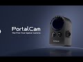
The First True Spatial Camera

What is a Spatial Camera?
PortalCam captures real spaces as photorealistic 3D worlds. Powered by 3D Gaussian Splatting, PortalCam turns any location into interactive spatial models you can walk through, edit, and share. This is how content gets made now.

How PortalCam Works?

Perfect Spatial Structure
Advanced sensing ensures accurate spatial relationships from intimate interiors to expansive street views.

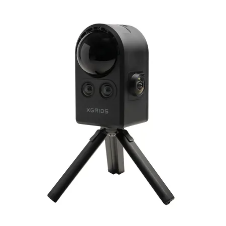
Complete Visual Coverage
Dual fisheye cameras capture every angle while dual front cameras preserve fine detail down to readable text.

Advanced Spatial Computing
Proprietary algorithms and onboard processing fuse all sensors into spatial models that scale without losing detail.

Three Steps to Spatial Content
• Capture: Walk naturally while PortalCam records. Monitor via LCC Scan app
• Process: Generate 3D models with automatic processing in LCC Studio
• Apply: Edit, share, and integrate LCC models with existing workflows

True 3D Content in Action

Real Estate - Let Buyers Move in before They Buy

True-to-Life Digital Replicas
Let buyers navigate naturally through every room with accurate lighting and measurements.

Efficient Property Capture
Digitize a 3,000 sq ft multi-story property in 15 minutes at walking speed.

Simple Link Sharing
Buyers get to visualize furniture layouts and explore spaces on any device.

Close Deals Faster
Confident buyers make quicker decisions when they truly understand the space.

Film Production - Shoot a Feature Film in 24 Hours

Remote Location Management
Directors, producers, and departments make decisions from anywhere, without multiple site visits.

Easy Pre-Visualization
Test lighting setups, camera moves, and blocking decisions in captured environments.

Virtual Production Ready
PortalCam delivers spatially accurate environments for LED walls and green screens with realistic perspective shifts.

Slash Production Costs
One scan reduces location scouting, rehearsal time, and costs while enabling unlimited studio takes.

Content Creation - Pioneer Immersive Storytelling

Democratized World Building
Anyone can create 3D worlds now. Just walk, scan, and process.

Seamless Workflow Integration
Diverse SDKs enable compatibility with Unreal Engine, Unity, web and more.

Interactive Audience Engagement
Your viewers get to explore spaces and experience stories across VR, AR, web, and mobile platforms.

Unlimited Asset Library
Every location becomes reusable content-mix, modify, and repurpose real spaces for infinite possibilities.

Personal Memory - Memories Should Not Have Missing Pieces

Relive Any Moment Completely
Revisit personal landmarks, big days, or any cherished moment in the exact space.

Capture Every Detail That Matters
One scan preserves complete spatial context-outfits, decorations, lighting, and atmosphere.

Create Living Family Archives
Transform moments into places your family can visit, sharing memories across generations.

Future Technology Ready
Immortalize moments to work seamlessly across current and future VR/AR devices.

LCC Studio

3DGS Processing
LCC Studio automatically generates publication-ready 3D Gaussian Splatting models from scan data using SLAM algorithms, sensor fusion, and model optimization, requiring minimal manual intervention.

LCC Format Output
Lightweight, streamable spatial models that work across platforms-from web browsers to VR headsets. Photorealistic, measurable, and ready for any workflow.

XGRIDS PortalCam Features

  • Spatial Camera Designed for Virtual Production
  • Highly Accurate Real-World Environment Capture
  • Ideal for Green Screen, Compositing, and LED Wall Workflows
  • 360 Degree Imaging for Location Scanning
  • Create Detailed 3D Digital Twins
  • Preview Camera Angles, Lighting, and Scene Blocking
  • Generate 3D Models with LCC Studio
  • Compatible with Unreal Engine, Unity, and After Effects

Key Features

  • Capture breathtaking aerial photos with exceptional image quality from its 4-camera array.
  • Experience superior stabilization, ensuring smooth, professional-grade drone camera footage every time.
  • Achieve incredible detail with the 4000 x 3000 px image resolution, perfect for mapping and inspections.
  • Benefit from a wide field of view, ideal for comprehensive surveying and immersive panoramic shots.
  • Enjoy extended flight times with the efficient battery, allowing for longer creative drone photography sessions.
  • Store all your adventures with the generous 512GB internal storage, keeping your aerial footage safe.

What's in the box:

  • XGRIDS PortalCam LiDAR Scanner
  • Battery
  • Tripod
  • Battery Charger with Cable
  • Protective Cover
  • Mobile Phone Mount
  • LCC Basic License Activation Card
  • Cleaning Cloth
  • Protective Case
  • User Manual
  • XGRIDS 1 Year Limited Warranty