Drone Software
Save 5% Every Day† with the Adorama Edge Card. Learn More
Drone Software
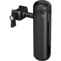
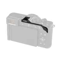
Moment Universal Mobile Cage Grip with NATO Mount
SKU: MO107146MFR: 107-146
(13)- Secure mobile grip for content creation.
- Durable build for smartphones on the go.
- Compact design, high-performance filming.
- Reliable Moment accessory for videography.
- Enhance phone stability with NATO mount.

Lian-Li Strimer Wireless 3x8-Pin RGB GPU Power Extension Cable, 12 Light Guides
SKU: LIPW121WMFR: PW12-1W
(2)- Vivid RGB illumination: 12 light guides.
- Addressable RGB GPU extension cable enhances PC.
- Optimal for 8-pin GPU connections. High performance.
- Durable silicone/TPE construction for reliability.
- Wireless design ensures effortless, perfect fit.
Ships from Manufacturer
?
Free Shipping
Microsoft 365 Family 1-Year Subscription for PC/Mac/iOS/Android, 6-User,Key Code
SKU: MIEP232327MFR: EP2-32327
(6)- Office 365: Streamlined 6 PC/Mac license.
- Efficient Performance: Boost productivity reliably.
- Microsoft Brand: Trusted software, great value.
- Simple Setup: Instant 12-month access download.
- Durable & Reliable: Consistent software experience.
Ships from Manufacturer
?
Free Shipping
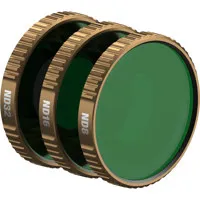
Polar Pro Shutter Collection ND Filter Kit for DJI Osmo Action 6 Camera
SKU: PPACTN6SHUTTMFR: ACTN6-SHUTTER
(4)- Durable action camera filters, superior protection.
- Optical clarity for pristine DJI Action 6 footage.
- Effortless installation on Osmo Action 6 lenses.
- Scratch-resistant glass ensures lasting quality.
- Waterproof design, reliable underwater filming.
FREE 2-Day Shipping
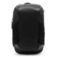
Peak Design 40L 2-in-1 Travel Backpack
SKU: PD2N1
(3)- Weatherproof design ensures durable protection
- Enjoy a comfortable fit with adjustable straps
- Multiple configurations offer ample storage
- Stylish designs available in several colors
- Resistant materials for weather protection
FREE 2-Day Shipping
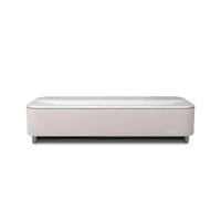
Epson Lifestudio Grand Plus 4K UHD Ultra Short-Throw 3-Chip 3LCD Laser Projector
SKU: IESLSGRNDPL
(1)- Experience stunning 4K UHD picture quality.
- Up to 4,000 lumens for brilliant display clarity.
- Ultra Short-Throw design fits any entertainment space.
- Seamless connectivity with multiple port options.
- Advanced laser projection ensures lasting performance.
FREE 2-Day Shipping
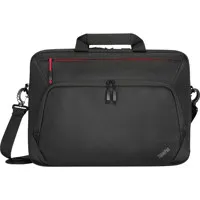
Lenovo ThinkPad Essential Plus Eco 15.6" Laptop Toploader Carrying Case, Black
SKU: LE4X41A30365MFR: 4X41A30365
(226)- Durable protection for your Lenovo laptop.
- Comfortable carry with padded shoulder straps.
- Ample storage for all laptop accessories.
- Stylish design elevates your professional look.
- Secure fit keeps your laptop snugly in place.
Ships from Manufacturer
?
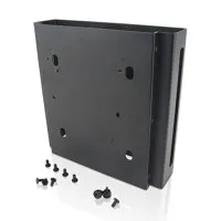
Lenovo Sandwich Kit II Mounting Bracket for ThinkCentre Tiny Desktop,Workstation
SKU: LE4XH0N04098MFR: 4XH0N04098
(18)- Robust mount ensures monitor stability and security.
- Effortless setup with easy-install monitor stand.
- Optimize viewing with flexible monitor adjustments.
- Maximize desk space with slim-profile monitor mount.
- Integrated cable management for a tidy workstation.
Ships from Manufacturer
?
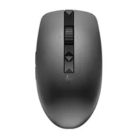
HP 635 Multi-Device Wireless Mouse, Nightfall Black
SKU: IH1D0K2AAABAMFR: 1D0K2AA#ABA
(11)- Multi-device wireless mouse for versatile connectivity.
- Ergonomic design ensures exceptional comfort and grip.
- Adjustable DPI up to 3000 for precise control.
- Programmable buttons for enhanced productivity tasks.
- Durable build quality guarantees long-lasting performance.
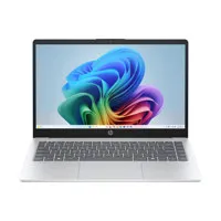
HP OmniBook 3 14-ha0365nr 14" FHD Laptop, Ryzen AI 5 340, 16GB, 512GB SSD, W11H
SKU: IHBH4H2UAABAMFR: BH4H2UA#ABA
(17)- Vivid 14" Full HD display for crisp visuals.
- Efficient AMD Ryzen AI 5 Processor performance.
- Robust 16GB RAM for seamless multitasking.
- Fast 512GB SSD storage for rapid data access.
- Extended laptop battery life up to 9 hours.
Ships from Manufacturer
?
Free Shipping
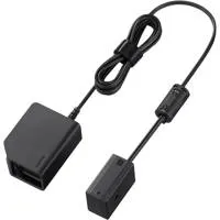
Sony DC-C2 DC Coupler for NP-SA100 Battery
SKU: ISODCC2MFR: DC-C2
- Efficient camera power solution for Sony NP-SA100.
- Reliable camera battery charging and performance.
- Seamless NP-SA100 battery compatibility charger.
- Compact charger design for easy photography travel.
- Durable charger construction ensures lasting power.
FREE 2-Day Shipping
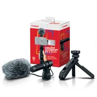
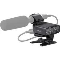
Canon Creator Accessory Kit II
SKU: ICACAK2MFR: 7497C002
- Compact and lightweight unidirectional stereo (120 Degree ) microphone
- Wind screen helps reduce peripheral sound from wind and other outside noise
- Mounts to the multifunction hot shoe creating a digital connection to the camera
- Compact tripod grip provides stable base to help you frame your subject and minimize shake
- Bundled Wireless Remote Control BR-E2 gives you creative control
FREE 2-Day Shipping
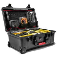
Pelican 1510 Waterproof Wheeled Studio Hard Case
SKU: PL0151000340MFR: 015100-0340-110
- Ultimate protection: impact-resistant hard shell.
- Weatherproof sealing for secure gear storage.
- Durable, long-lasting hard case construction.
- Secure latching system for reliable closure.
- Customizable foam interior for perfect fit.
FREE 2-Day Shipping
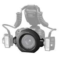
Canon AD-M1-MA Macro Flash Head Adapter
SKU: CAADM1MAMFR: 7626C001
- Ensures flash compatibility and performance.
- Durable build offers long-lasting reliability.
- Connects Macro Twin Lite swiftly.
- Adapter design provides exceptional flexibility.
- Guarantees reliable flash connection.
FREE 2-Day Shipping
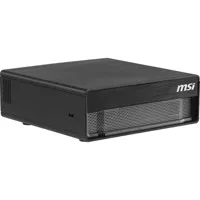
MSI EdgeXpert-13SUS Desktop AI Computer, NVIDIA GB10,128GB,4TB,NVIDIA GPU,DGX
SKU: MSIEDGEXT13SMFR: EDGEXPERT13S
- NVIDIA GB10 processor for powerful AI computing.
- 128GB RAM for seamless multitasking on Desktop.
- 4TB SSD storage for extensive data capacity.
- NVIDIA GPU enhances graphics and performance.
- NVIDIA DGX operating system optimized experience.
Ships from Manufacturer
?
Free Shipping

DJI FlightHub 2 Enterprise Version Package, 3-Year Subscription, 1-Device
SKU: DJICPRJ19301MFR: CP.RJ.00000193.01
Download Version
- DJI FlightHub 2 Enterprise: Latest technology
- 3-year subscription: exceptional value for money
- Comprehensive flight management: streamlined workflow
- Adorama exclusives: professional drone solutions
- Dedicated 1-device support: premium assistance
Sony Digital XLR Adapter Kit with 32bit Float for a7R VI Camera
SKU: ISOXLRA4MFR: XLR-A4
- Ensures superior audio quality for pro recordings.
- Seamless compatibility with Sony a7R VI camera.
- Durable design for reliable field performance.
- Effortless setup for enhanced ease of use.
- Versatile connectivity for diverse audio gear.
Free Expedited Shipping
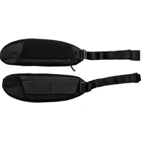
Peak Design Travel Hip Belt Pack
SKU: PDBTRHBBK2MFR: BTRHB-BK-2
- Secure camera attachment for adventures.
- Comfortable weight distribution, travel-ready.
- Durable, long-lasting nylon construction.
- Adjustable length for optimal fit.
- Quick-release buckles for swift access.
2-Day Shipping - FREE on Orders over 49.99
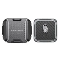
PGYTECH Shoulder Strap Quick Release Clamp with Plate
SKU: PGPCG189MFR: P-CG-189
- Secure camera Quick-Release Clamp. Essential.
- Aluminum alloy build ensures lasting durability.
- Reliable PGYTECH clamp supports 66.1 lbs easily.
- Effortless camera attachment for photography pros.
- Portable quick release clamp. Travel-friendly gear.
SmallRig Thumb Grip for Panasonic LUMIX L10 Camera, Black
SKU: SR5702MFR: 5702
- Improved grip for Panasonic LUMIX L10 Camera
- Durable Aluminum Alloy build quality ensures longevity
- Ergonomic design for enhanced camera handling
- Easy installation; instantly boosts control
- Secure camera attachment for stable shooting
Free Shipping
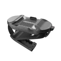
PGYTECH Beetle Camera Clip V2
SKU: PGPCG194MFR: P-CG-194
- Secure your camera: Durable, high-quality aluminum design.
- Advanced dual-lock safety prevents accidental release.
- Enhanced Compatibility for various camera brands.
- Strong 66lb load-bearing for professional gear.
- Reliable PGYTECH Warranty Support included.
2-Day Shipping - FREE on Orders over 49.99
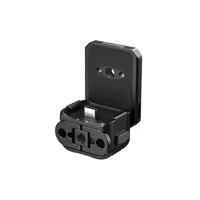
SmallRig Attachable Quick Release Backplate Mount w/USB-C for Osmo Pocket 3/4
SKU: SR6359MFR: 6359
- Quick Release Backplate: Osmo Pocket 3/4 Camera
- Secure Mount for DJI Osmo Pocket: Enhance setup
- USB-C Port for seamless connectivity and charging
- Robust Aluminum Alloy Construction: Durability
- Optimal Compatibility with DJI Osmo Pocket Series
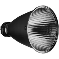
Profoto PowerBeam 20 Degree Reflector
SKU: PP100812MFR: 100812
- Precise 20 degree beam angle for focused light.
- Profoto mount ensures stable, seamless integration.
- Durable reflector delivers consistent light output.
- German engineered for superior optical performance.
- Circular design provides even light spread.
FREE 2-Day Shipping
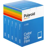
Polaroid Color 600 Instant Film, 40 Exposures, 5-Pack
SKU: PD006013MFR: 006013
- Polaroid 600 film captures vivid color.
- Instant film delivers 40 exposures.
- Quick 10-15 min development time.
- Compatible with Polaroid 600 cameras.
- High-quality, long-lasting images.