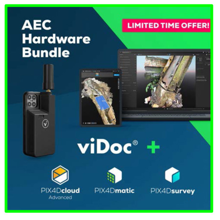
Pix4D AEC Hardware Bundle with viDoc RTK Rover for Smartphone, Yearly License
SKU: P4DAECHB
This item is no longer available.
Recommended Alternatives
Share:
Overview
Compare
Specs
Protection
About Pix4D viDoc RTK Rover
Annual license for the ultimate AEC hardware software bundle.
Get centimeter accurate terrestrial scans with the viDoc, and process results with PIX4Dmatic. Seamless integration between desktop and cloud 2D and 3D processing for advanced project analysis. Leverage the power of both photogrammetry and terrestrial LiDAR for fast terrestrial, corridor, and large scale mapping with PIX4Dmatic. Apply advanced automation to extract the data you need from point clouds and create CAD-ready deliverables with PIX4Dsurvey. PIX4Dmatic and PIX4Dsurvey combined with our online platform for terrestrial and drone mapping allow streamline progress monitoring, site documentation, and collaboration.
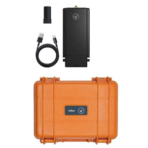
- viDoc RTK rover -
For selected iPhone and Android devices.
The future of single point measurement with 3D scanning
Use a handheld RTK rover to elevate single point measurement with 3D scans
Multiple options for accurate point measurement
Measure with the laser, photogrammetry, or attach it to a surveying rod.
Measure obstructed points
Complete data collection without missing anything that may be obstructed by objects like trees or overhangs.
Accurate and safe measurement methods
Get your measurements and reduce risks - cut unnecessary trench visits, etc. Make data collection safer.
The viDoc RTK rover with PIX4Dcatch
Accurate surveying with a mobile device
Easy field-to-finish workflows
Easy digitalization with Pix4D software that can measure single points or create line work from data capture.
RTK positioning rover for 3D scanning
viDoc RTK rover pairs with the PIX4Dcatch to geotag images of the 3D scan in real-time using NTRIP services.
Enhanced mobile data collection
viDoc connects to over 600 channels (including all major constellations such as GPS, GLONASS, Galileo, etc.) which results in convergence in under 5 seconds.
Replacing complex workflows
Ground surveying equipment like laser scanners can be expensive, bulky, and highly technical. Drones can be restricted by regulations. Overcome the obstacles with a handheld rover.
A complete, accurate workflow in your hands
The viDoc, the smartphone, PIX4Dcatch, and PIX4Dcloud. An end-to-end solution that gets measurements at centimeter level absolute accuracy.
Intuitive feel and structure
Easy for anyone to collect points or complete an accurate 3D scan. The handheld rover combines with mobile software to create digital twins as fast as possible.
- PIX4Dmatic -
Next-generation photogrammetry software for terrestrial, corridor and large scale mapping
Are you ready to go big?
The optimized software for the next surveying and mapping challenges
Bigger datasets, accurate results
PIX4Dmatic processes thousands of images while maintaining survey-grade accuracy, halving the processing time, without the trouble of splitting and merging.
Fully automated processing
Developed in close-collaboration with surveyors and mapping professionals to streamline your workflow: import, process and assess the quality of a project in just a few clicks, and move seamlessly from PIX4Dmatic to PIX4Dsurvey.
Terrestrial workflow
Leverage the benefits of both photogrammetry and LiDAR technology. Process LiDAR and RGB image outputs from PIX4Dcatch for a full terrestrial workflow. Easy and desktop-based.
Accurate 3D maps and models from thousands of images
Fast processing
Handling and processing large amounts of data is easy with PIX4Dmatic. Get your results up to 50% faster, while keeping a survey-grade accuracy.
Easy accuracy checks
Ensure the accuracy of your project with GCPs, Checkpoints, or Manual Tie Points. Accuracy metrics are available in a dedicated tie points table and in an exportable quality report.
Vertical coordinate systems and geoid support
PIX4Dmatic supports the most frequently used vertical coordinate systems and their corresponding geoids.
Import from PIX4Dcatch
Process both LiDAR and RGB image outputs from PIX4Dcatch.
Fast development cycles
Updates are released every three weeks in a new preview or stable version, ensuring you get all the latest improvements and features.
- PIX4Dsurvey -
Bridge the gap between photogrammetry and CAD
Capture
Capture images or point clouds with a drone or any laser scanner. When using a drone, automate and optimize your flights with the free PIX4Dcapture mobile app.
Import
Import data from other Pix4D software or a .las or .laz file to PIX4Dsurvey and combine multiple datasets into the same project. Work with both imagery data and LiDAR point clouds.
Vectorize
Generate a TIN to model the ground and create engineering-ready CAD vector files from point cloud data by extracting key elements of your project with PIX4Dsurvey.
Model
Move from a lightweight point cloud to a model of your terrain. Use the Smart Grid, TIN, and terrain classification to get accurate, actionable results
Integrate
Open your simplified, accurate data in any CAD or GIS software with custom layers and properties that fit your existing workflow.
Beyond the point
Extract only the most relevant information to speed up and simplify your surveying workflows
Vectorize anything
Use the combined power of images and point clouds to extract key elements from photogrammetry, laser scanning or LiDAR data. Survey curbs, building footprints, walls, catenary curves and more.
Time-saving benefit
Work 50% faster when you vectorize from point clouds and verify in images, while the Smart Grid saves 1,000s of clicks creating spot elevations.
CAD ready
Include layers and properties for a smooth transition to CAD or GIS and reduce file size when exporting your projects as vector files.
Volume measurements
Create and measure the volume of any object, even against a wall or in a corner, with fast, simple steps.
Extract key elements in 3D
Built-in vectorization tools
Vectorize your project using points, polylines, polygons and catenary curves with just a few clicks.
Measure volumes
Measure the volume of any object or space with straightforward steps.
Create surfaces
Model the ground with a TIN from points and breaklines to represent the topography of your project. Automate the creation of spot elevations and allow drastic simplification of the number of point cloud points.
Unlock more data
Move beyond photogrammetry, yet still work with Pix4D's rayCloud to access the original images and 3D point clouds simultaneously. Vectorize in 3D, edit in 2D. Survey complex objects only visible in images. Use color selection to pick a point and search in a defined radius for points of a similar color.
Scale up
PIX4Dsurvey can handle billions of points. Work with as many point cloud files as you like in the same projects, including .las.
Integrated solution
PIX4Dsurvey works with your existing workflows. Import .p4d files from PIX4Dmapper, PIX4Dcloud, or .p4m files from PIX4Dmatic with the click of a button, or work with .las and .laz files from any device/source.
Easy export
Every surveyed object can be assigned to a layer and edited. Layers can be exported separately or together for a smooth transition to your preferred CAD or GIS software.
Your choice of point cloud
Import projects from PIX4Dcloud, PIX4Dmatic, PIX4Dmapper or any .las or .laz file.
Aerial data
Create a point cloud from images in PIX4Dcloud, PIX4Dmapper or PIX4Dmatic, and drag and drop the .p4d or .p4m file to PIX4Dsurvey.
Laser scanner or LiDAR
PIX4Dsurvey works with multiple point clouds at the same time formatted as an .las or .laz file.
- PIX4Dcloud Advanced -
The online platform for ground and drone mapping, progress tracking, and site documentation
Capture
Collect site images using PIX4Dcatch, viDoc RTK rover, drones, handheld cameras or the Pix4D CraneCamera.
Process
Automatically process your images on the cloud using photogrammetry algorithms to transform them into measurable deliverables. Generate accurate and georeferenced orthomosaics, 3D meshes, point clouds, and elevation models.
Analyze
Visualize, monitor and document site progress using an intuitive interface, a timeline, and built-in measurement tools, accessible online from any device or location, on a collaborative cloud-based platform.
Share
With a simple URL, share the results with your team or clients to ensure seamless information flow and greater collaboration.
Integrate
Download all outputs and export to third-party CAD and BIM software for further steps.
Professional photogrammetry on the cloud
Accurate results
Rely on Pix4D's processing algorithms to get the survey-grade results you expect. Choose the AutoGCPs feature for even greater accuracy.
Analysis made easy
Get an instant view of any jobsite from anywhere, on your browser, in 2D and 3D, with results you can measure, explore, compare, share and collaborate on.
Up-to-date documentation
Keep a permanent and up-to-date record of the project and resolve disputes efficiently.
Pix4D viDoc RTK Rover Features
- viDoc RTK rover Features
- Use a handheld RTK rover to elevate single point measurement with 3D scans
- Multiple options for accurate point measurement
- Measure obstructed points
- Accurate and safe measurement methods
- PIX4Dmatic Features
- Fast processing
- Easy accuracy checks
- Vertical coordinate systems and geoid support
- Import from PIX4Dcatch
- Fast development cycles
- Pix4Dsurvey Features
- Vectorize anything
- Time-saving benefit
- CAD ready
- Volume measurements
- Pix4Dcloud Advanced Features
- Track and document site progress with visual Timeline
- Increase accuracy with AutoGCPs
- Compare volumes over time
- Overlay design plans and maps
- Compare two image maps to see what has changed