


+12
more
more
See Options
Need help? Ask our experts.
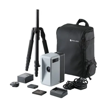
This bundle includes additional accessories and 300 software credits for 3D tour hosting (one credit keeps one tour active per month) and deliverables downloads (point clouds, OBJ files, RAW files, etc.).
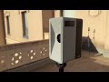
Elevate real estate (commercial and residential), construction, architecture, and engineering projects with the Realsee Galois M2 3D LiDAR Camera. Designed for both indoor and outdoor use, Galois delivers exceptional precision and high-resolution results for immersive 3D tours.
Equipped with a 940nm LiDAR and a large 4/3-inch CMOS sensor, it captures detailed 3D scans and vibrant 2D images. Automatically generate immersive 3D tours, dollhouse views, floor plans, RAW images, and 16K panoramas.
Key Highlights
• 940nm LiDAR with < +/-20 mm error (at 10m)
• 134MP high-resolution color imaging
• 25m scanning radius
• Multiple exports: point clouds, 3D models, RAW files, 16K panoramas, floor plans
• 8-hour battery life | Portable 2.66 kg design
The free Realsee VR app (available on the Realsee website) is required to operate the Galois camera.
Indoor & Outdoor Immersive 3D Tours
Galois uses a 940nm laser wavelength, making it resistant to light interference. It performs reliably in any lighting-indoors or outdoors, bright or low-light-for consistent data capture across diverse environments.
High-Precision LiDAR Scanning
Equipped with high-accuracy LiDAR, Galois captures spatial data up to 25 meters away with a 360 Degree x 155 Degree field of view. It delivers precise point clouds with an error margin under +/-20 mm.
134MP High-Resolution Imaging
A 4/3-inch CMOS fisheye lens enables Galois to capture 134-megapixel color panoramas, ensuring exceptional image clarity and fine detail.
Versatile Output Formats
Galois supports a wide range of deliverables:
• Precision Data: Point clouds (.ply, .e57) and 3D models (.obj, .fbx), compatible with Autodesk and Cloud Compare
• Marketing Materials: Immersive 3D tours, RAW images, 16K panoramas, videos, 3D snapshots, and ready-made floor plans
Flexible Pay-As-You-Go Hosting
Publish 3D tours by purchasing credit packages-no monthly subscription required.
• Credits are valid for one year
• Capture and upload are free; credits are only used when publishing
• One credit keeps one tour active per month
• Free reactivation and unlimited editing
• Download images, videos, and floor plans at no extra cost
All-in-one 3D Tour Editing Toolkit & Share It Anywhere
Comprehensive Free Editing
Access a full suite of editing tools at no cost. Enhance your tours with multimedia tags, floor plan editing, Google Street View integration, video fusion, and panorama optimization.
AI-Powered Automation
Leverage smart AI features for effortless editing, including automatic camera removal and seamless patching of the zenith (top) and nadir (bottom) areas.
Cross-Platform Editing
Start with quick edits on the mobile Realsee App, then switch to the powerful Realsee Console Editor on your PC for advanced professional adjustments.
Easy Publishing & Sharing
Once your 3D tour is ready, activate and share it effortlessly across multiple platforms. Showcase your space on Google Street View, social media channels, or by embedding the tour link directly into your website.
Note: The default password for the Galois M2 app is 0000000000 (10 zeros), which is also noted in the Realsee VR app.