


This item is no longer available.
Map without limits
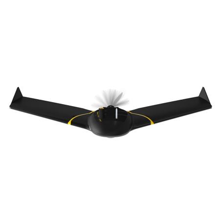
The senseFly eBee X is the fixed-wing drone for all your mapping needs. It is designed to boost the quality, efficiency, and safety of your data collection and has a camera to suit every job. The coverage and accuracy is designed to meet every project's requirements and can work on virtually every type of site.
Efficient and Precise
The eBee X can meet the exacting requirements of every project. Its unique Endurance Extension unlocks a maximum flight time of 90 min-for vast coverage of up to 500 ha (1,235 ac) at 400 ft-while its High- Precision on Demand helps you achieve an absolute accuracy of down to 3 cm (1.2 in), without GCPs.
Rugged and Reliable
The eBee X allows you to work virtually every site, no matter how demanding, thanks to its space-friendly Steep Landing technology, ultra-robust design, live air traffic data and more-all backed by senseFly's trusted professional, local support.
Multi-purpose
The eBee X suits every job thanks to its range of groundbreaking cameras. These include the new senseFly S.O.D.A. 3D, for stunning 3D reconstructions of vertical environments, the best-in-class senseFly Aeria X RGB photogrammetry camera and the senseFly Duet T for creating geo-accurate thermal maps.
senseFly S.O.D.A
The senseFly S.O.D.A. is the first camera to be built for professional drone photogrammetry and has quickly become the reference sensor in its field. It captures amazingly sharp aerial images, across light conditions, with which to produce detailed, vivid orthomosaic images and ultra-accurate 3D digital surface models.
senseFly S.O.D.A. 3D
The senseFly S.O.D.A. 3D is a unique innovation-a professional drone photogrammetry camera that changes orientation during flight to capture three images (2 obliques, 1 nadoptimized time, instead of just one, for a much wider field of view. It is optimized for quick, robust image processing with Pix4Dmapper.
senseFly Aeria X
The senseFly Aeria X is a compact drone photogrammetry powerhouse. This rugged innovation offers the perfect blend of size, weight, and DSLR-like image quality. It offers stunning image detail and clarity, in virtually all light conditions, allowing you to map for more hours per day than ever before.
senseFly Duet T
The senseFly Duet T is a rugged dual-camera thermal mapping rig. Use it to create geo-accurate thermal maps and digital surface models quickly and easily.
senseFly Corridor
senseFly Corridor simplifies the drone mapping of linear infrastructure and sites. This integration kit houses the senseFly S.O.D.A. (not supplied) in a longitudinal, or portrait, position, while senseFly Corridor flights are managed via the corridor mapping mission block within eMotion 3.
Parrot Sequoia+
Parrot Sequoia+ is the smallest, lightest multispectral sensor ever released. It captures images across four defined, visible and non-visible spectral bands, plus RGB imagery, in just one flight.
Simplicity meets power
Beginner-friendly, yet packed with advanced features to optimize results, eMotion helps you get your drone in the air quickly, while including all the functionality you need to collect and manage exactly the geospatial data you require.
Flexible
eMotion is the only professional-grade drone software to support both fixed-wing and multirotor operations. It includes intuitive mission planning blocks and flight modes to suit every application, from automated eBee mapping flights to up-close Albris inspections.
Full 3D environment
eMotion's full 3D environment adds a new dimension to drone flight management-helping you to more accurately plan, simulate and control your drone's trajectory for safer flights, more consistent performance and improved data quality.
Connected
eMotion 3 is an ever-evolving workflow hub. It connects wirelessly to your drone, to industry cloud solutions, to survey-grade base stations, airspace data, and even includes live weather updates.
Plan:
With eMotion, flights are built using mission blocks. Just choose your block (aerial mapping, corridor etc.), highlight the region you want to map, define key settings, and eMotion auto-generates your drone's flight plan. Multi-flight missions are supported and you can activate/import elevation data for even safer, terrain-accurate flights.
Simulate:
eMotion's Simulator mode helps you to optimize your flight plan and explore the functions of your senseFly drone. Just enter the wind strength and direction, then press Play to 'launch' your drone. Now you can view all aspects of your flight as the drone flies its mission.
Fly:
Upload your flight plan wirelessly to your drone. After a simple hand launch, eBee fixed-wing drones then fly, capture images, and land themselves. For Albris, choose between an automatic mapping mission or eMotion's Interactive ScreenFly mode for live inspections.
Export:
eMotion's built-in Flight Data Manager automatically handles the georeferencing & preparation of images required for post-processing in software such as Pix4Dmapper (vastly reducing third-party software compatibility issues).