+4
more
more

See Options
Need help? Ask our experts.
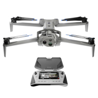
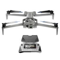
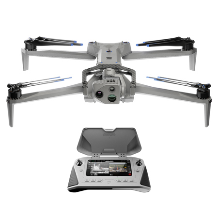
Are you ready to elevate your aerial photography and videography to new heights Introducing the advanced X10 Drone Starter Kit with Cellular 5G, Visible Light Navigation Camera, and VT300-L Sensor Package. This high-tech drone is designed with the most sophisticated AI in the sky, offering unparalleled capabilities for professional and enterprise-level use.
The X10 Drone is equipped with a state-of-the-art 4K gimbal camera, built-in camera, and thermal camera, all designed to deliver high-resolution footage and images. The drone's 3-axis gimbal ensures smooth, stable footage, setting it apart from its competitors.
Designed for demanding tasks, the X10 Drone boasts a longer flight time of up to 40 minutes and can handle heavier payloads, making it ideal for commercial use. Its enterprise-level capabilities are backed by an onboard NVIDIA Jetson Orin GPU, providing unrivaled computing power for real-time decision making.
This innovative drone is the first to integrate a FLIR Boson+ sensor, delivering the highest quality thermal imaging. With resolutions of 640 x 512 px and increased sensitivity, the X10 Drone brings the sharpest details to every decision.
The X10 Drone's custom-designed navigation lenses provide 360-degree visibility, eliminating blind spots for fearless flying in any environment. Its superior AI flight assistance and obstacle avoidance features make it easy to navigate complex missions confidently, even in GPS-denied or high EMI environments.
The X10 Drone also offers automated complex missions with its new Spatial AI Engine that senses and understands what you're scanning. It can efficiently build 2D maps and 3D models onboard in real time, or export data to Pix4D, Bentley iTwin Capture, DroneDeploy, or ESRI SiteScan.
The X10 Drone is not just advanced; it's also adaptable. With modular sensor packages and four attachment areas, it can swiftly adapt to changing mission requirements. Whether you need to mount a parachute, microphone, spotlight, or more, the X10 Drone is ready to customize for your mission.
Designed to withstand harsh conditions, the X10 Drone features a lightweight and durable magnesium and carbon fiber frame, coupled with an innovative graphite heat-spreading system. It's IP55 certified against dust and water, can handle wind gusts up to 28.6 mph, and operates in temperatures ranging from -4 to 113 degrees Fahrenheit.
The X10 Drone Starter Kit with Cellular 5G, Visible Light Navigation Camera, and VT300-L Sensor Package is more than just a drone; it's a game-changer in aerial photography and videography. Experience the future of drone technology today with the X10 Drone.
https://www.skydio.com/legal/limited-warranty
855-463-5902