+4
more
more

See Options
Need help? Ask our experts.
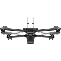
After meticulous engineering and design, the X10 Drone emerges as a paragon of aerial innovation, equipped with Cellular 5G connectivity and a Visible Light Navigation Camera. This high-tech marvel is not just a drone; it's a sophisticated flying sensor platform, boasting the most advanced AI in the skies. The X10 Drone is a testament to state-of-the-art technology, offering unparalleled image capture with its visionary cameras that outperform any other drone of its size in both megapixels and optics.
The X10 Drone's modular sensor packages, including the VT300-L Sensor Package, are tailored to capture the exact details required for your professional tasks. With high-resolution visual and radiometric cameras, the X10 Drone ensures that every pixel serves a purpose, delivering crisp and detailed imagery for precise inspections and mapping.
Experience unrivaled thermal imaging with the integration of the FLIR Boson+ sensor, a first for drones of this caliber. The sensor's 640 x 512 px resolution and enhanced sensitivity reveal the sharpest details, elevating your decision-making process with accurate thermal data.
Our custom-engineered lenses are a cut above off-the-shelf components, providing unmatched resolution and focus. These unique lenses, combined with the powerful Spectra 480 image signal processor, enhance white balance, reduce noise, extend HDR capabilities, and ensure pixel-perfect images every time.
Zoom into your subjects without sacrificing image quality, thanks to the compact transition zoom system that maintains clarity even when fully zoomed in. Capture outstanding low-light images with custom wide aperture lenses, allowing significantly more light than competitors, ensuring faster exposure times and clearer results.
The onboard NVIDIA Jetson Orin GPU empowers the X10 Drone with extraordinary computing power, enabling real-time decision-making and 360-degree visibility with six custom-designed navigation lenses. This eliminates blind spots and allows for fearless flight in any environment.
Navigate complex missions with ease, even in GPS-denied or high EMI areas, thanks to superior AI flight assistance and obstacle avoidance. The X10 Drone's Spatial AI Engine automates targeted inspections, builds 2D maps and 3D models in real-time, and seamlessly exports data to industry-standard software like Pix4D and DroneDeploy.
The X10 Drone's AI capabilities are designed to evolve, enhancing its data capture and synthesis over time. And with NightSense mode, the drone confidently operates in zero-light conditions, using visible or infrared illumination to navigate and avoid obstacles, making it a true 24/7 operational tool.
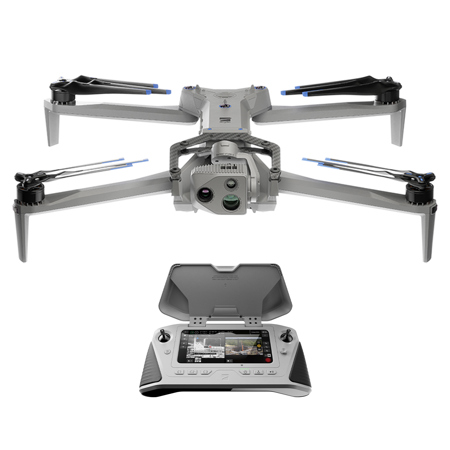
Ultimate control is intuitive with the Skydio X10 Controller and Flight Deck, allowing you to plan, execute, and review missions with precision. Remote Flight Deck capabilities enable you to launch and fly the drone from a browser, offering unparalleled flexibility in operation.
Skydio Connect technology ensures robust and reliable connectivity, whether you're flying locally with Skydio Connect SL, remotely over 5G with Skydio Connect 5G, or in contested environments with Skydio Connect MH. The redesigned Skydio Flight Deck app provides a professional-grade interface, allowing for swift and focused mission execution.
The X10 Drone is an open modular platform, ready to adapt to your mission requirements with attachments such as spotlights, microphones, parachutes, and RTK GPS. Its compact size, quiet propulsion, and durable materials make it an ideal choice for one-person operation in any environment.
The VT300-L Sensor Package enhances the X10 Drone's capabilities, featuring a 64MP narrow module, a 1" wide module with an LED flashlight, and the FLIR Boson+ radiometric module, perfect for detailed mapping and inspections in low-light conditions. The FLIR Boson+ sensor's increased sensitivity marks a significant advancement in thermal imaging precision.
In summary, the X10 Drone with Cellular 5G, Visible Light Navigation Camera, and VT300-L Sensor Package is an advanced, high-tech solution for professionals seeking sophisticated, innovative, and state-of-the-art aerial photography and videography capabilities. With its long flight time and advanced features, it stands out as a superior choice in the realm of enterprise-level drones.
https://www.skydio.com/legal/limited-warranty
855-463-5902