
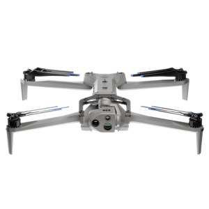
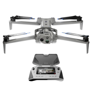
Skydio X10 Cellular 5G Drone Starter Kit with Battery, Visible Light Navigation Camera and VT300-L Sensor Package
SKU: SKYDR4E1BS2L
This item is no longer available.
Recommended Alternatives


Share:
Overview
Compare
Accessories
Specs
Protection
About Skydio X10 VT300-L
- X10 Drone with Cellular 5G and Visible Light Navigation Camera -
You've never seen like this before.
The best sensors for a drone this small, piloted by the most advanced AI in the sky. To get the data you need, wherever and whenever you need it.
Visionary cameras to get the job done.
Packing more megapixels and better optics than any drone its size, Skydio X10 boasts high resolution visual and radiometric cameras in modular sensor packages. So you can capture the right details for your job.
Unrivaled thermal imaging.
Skydio X10 is the first drone ever to integrate a Teledyne FLIR Boson+ sensor, delivering the highest quality thermal imaging. Capable of resolutions of 640x512 and offering increased sensitivity down to <=30mK, X10 delivers more accurate radiometric readings, anywhere, anytime.
Unmatched thermal sensitivity
The Boson+ sensor is 40% more sensitive than comparable thermal units on the market
Unparalleled image clarity
640x512 thermal resolution combined with radiometry and advanced AGC enables the clearest thermal images
Sharper, clearer imagery
Onboard image optimization algorithms enhance detail in distant objects and improve overall aesthetic for easier interpretation
Detect temperature differences even on a hot day.
Detect a person on a roof in complete darkness.
The sensor packages on the Skydio X10 supercharge your sight, enabling you to capture it all in high-definition. Because the data is in the details.
Onboard AI. Off-the-charts capability.
Fly without limits or learning curves. With a drone that recognizes its surroundings, captures data automatically, and gets smarter over time.
Backed by an onboard NVIDIA Jetson Orin GPU, the X10 harnesses unrivaled computing power to make the right decisions in real-time. Six custom-designed navigation lenses provide 360-degree visibility, eliminating blind spots so you can fly fearlessly in any environment.
• 10X more computing power than the previous generation
• 10X more effective navigation pixels than the previous generation
• Onboard NVIDIA Jetson Orin GPU
Fly with ease.
Navigate the most complex missions confidently, even in GPS-denied or high EMI environments. With superior AI flight assistance and obstacle avoidance, you no longer need to hire a specialist to get the job done, whether you're in the field with your drone, or piloting from a hundred miles away.
Automate complex missions.
Complete targeted inspections automatically, with a Spatial AI Engine that senses and understands what you're scanning. Efficiently build 2D maps and 3D models onboard, in real time. Or export data to Pix4D, Bentley iTwin Capture, gNext, DroneDeploy, or ESRI SiteScan.
Get smarter over time.
Skydio X10 is loaded with the computing capacity for its AI data capture and synthesis capabilities to grow over time.
Another industry first: Autonomy in the dark.
Confidently operate 24/7 in NightSense mode for zero-light navigation - only available with the groundbreaking Skydio X10.
See in the dark.
Skydio X10 uses visible illumination to avoid obstacles, understand its environment, and make the right decisions, every time.
Visible Light Nav Cam and Illuminator.
Using visible illumination, the X10 provides bright 360 degree light.
Visible light Module
Conduct autonomous flight in the dark with visible light.
- Enterprise Controller -
Ultimate control becomes second nature.
Fly however you want.
Fly by controller.
Plan, execute, and review any mission with the Skydio X10 Controller and Flight Deck, our optimized flight application.
Fly by browser.
Launch and fly a drone from a browser with Skydio Remote Ops or Skydio DFR Command to eyes on any situation
Pass off piloting to a remote operator.
Hand over control to an offsite pilot any time with Skydio Remote Ops or Skydio DFR Command. The remote pilot can use a browser from any location to seamlessly pick up exactly where the onsite pilot initiated the handoff.
Fly wherever you need.
Skydio Connect SL - Fly with a local connection
Fly up to 7.5 miles with Skydio Connect SL, the redesigned direct link from controller to drone. Our proprietary technology maintains a reliable connection in congested areas and enables piloting at distances beyond visual line of sight.
Skydio Connect Fusion-Fly farther with 5G from a controller or browser.
Increase your range using Skydio Connect 5G wherever there's cellular coverage. You'll have continuous coverage from your controller, using point-to-point when in range with seamless transition to cellular when not. Add Remote Ops or DFR Command software and pilot from your browser.
Skydio Connect MH-Fly in contested environments.
Perform with minimal interference in contested environments, with Skydio Connect MH. Global support across six frequency bands, in-flight channel selectability, and AES-256 encryption, enable reliable connectivity anywhere.
7.5 miles
Count on optimum robustness and range from the Skydio third-generation wireless link.
Unlimited miles
Extend your range wherever there's a cellular connection.
An operator experience forged by thousands of flying hours.
Plan, execute, and review every type of mission on the redesigned Skydio Flight Deck app.
A pro-grade interface built from the ground up
Spend less time navigating menus to ensure faster operation during critical missions.
Do more with less distractions.
Navigation camera view.
See the 3D map the drone is creating in real time to fly with maximum confidence.
Modify the interface to suit your needs
See more and do more, with swappable layouts and customizable telemetry.
Always see what your drone sees
Maintain visibility of the drone's live preview, even while adjusting settings or receiving notifications.
Quickly access key functions
Get immediate access to thermal settings, attachment actions, and AR overlays.
See when conditions are changing
Receive notifications to keep track of fluctuating environmental conditions
Precision at your fingertips.
Upgraded connectivity, customization options, and a rugged design lets you respond to any situation with total control.
Customizable controls.
Get one-touch access to frequently used features.
Improved daytime visibility.
With 60% increase in screen brightness.
Ruggedized hardware.
IP54 weatherproofing protects from harsh conditions.
Robust connectivity.
Supports Skydio Connect for low-latency control from anywhere.
Integrated apps. So work just flows.
DFR Command
Start, operate and grow DFR programs.
Remote Ops
Automate your work from anywhere.
3D Scan
Capture 2D/3D models in the field.
Onboard Modeling
View 2D/3D models in real time.
An open modular platform.
With modular sensor packages and four attachment areas, the Skydio X10 swiftly adapts to changing mission requirements. Mount a parachute, speaker, spotlight and more, for a max payload of 12 oz.
Customize for your mission.
Spotlight
Improve visibility during nighttime operations.
Speaker
Communicate and coordinate in high-risk situations.
Parachute
Designed to meet requirements for safe flying over people.
RTK/PPK GPS
Get exceptional accuracy for precision mapping and data collection.
Ready for anything, anytime, anywhere.
Designed from the ground up to bring the performance of a heavy drone to a backpack portable device. Weighing under 4.7 pounds with a 13.8 inch length, the Skydio X10 folds into the most compact size of any drone with similar sensors, truly enabling one-person operation.
Quiet propulsion.
The efficient motors and folding 3-blade design of the Skydio X10 delivers a quiet flight profile while allowing for top speeds of up to 45 mph in stable air.
Lightweight materials.
A lightweight and durable magnesium and carbon fiber frame, coupled with an innovative graphite heat-spreading system, ensures the Skydio X10 can withstand harsh environments to deliver vital aerial intelligence, anytime.
Withstand wind, rain, dust. And the unexpected.
Always in its element.
Water and dust.
Ingress protection: IP55 certified against dust, water and the unexpected.
Wind.
Max gust handling: 28.6 mph / 43 kmh
Cold and heat.
Operational temperatures: -4 Degree to 113 Degree F / -20 Degree to 45 Degree C
Altitude.
Service ceiling: 15,000 ft / 4.57 km
- VT300-L Sensor Package -
VT300-L provides a 64MP narrow module, a 1" wide module with a LED flashlight, and a FLIR Boson+ radiometric module. A great choice for mapping structures and inspections in low light environments.
FLIR Boson+ is a radiometric thermal module offered with the VT300-L sensor packages. This sensor is 40% more sensitive than its predecessor, the FLIR Boson 320x256, so Skydio X10 operators will be able to see much greater detail and get much more precise radiometric measurements than they ever have before.
Skydio X10 VT300-L Features
- 45mph Max flight speed
- 40min Max flight time
- < 40 sec Deployment time
- IP55 Certified against dust and water
Warranty Information
This product has a limited warranty of 12 months for parts and 12 months for labor.
https://www.skydio.com/legal/limited-warranty
855-463-5902