+9
more
more
See Options
Need help? Ask our experts.
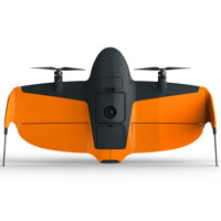
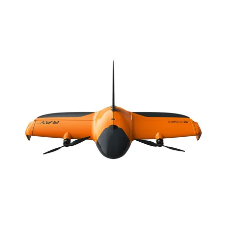
The survey drone built for faster results and total confidence in the field. WingtraRAY delivers what actually matters for real survey work
Fly with peace of mind - anywhere
Feel safe and confident, even over roads and populated areas.
Get your surveys done faster
Survey 100 ha (250 ac) in 10 min and deliver CAD-ready files in one smooth flow. No matter the time window, you'll get it done with fast data capture and a single workflow that gets you to deliverables in the same day.
• 40% Faster than the previous generation (WingtraOne GEN II)
• 10x Faster than multicopter drones
• 30x Faster than terrestrial methods
Take on more jobs with purpose-built sensors
Six swappable sensors for high-quality capture across a wide range of survey tasks.
Capture more in short time windows
Get the maximum coverage for your resolution
Adaptive speed automatically adjusts the drone's pace based on your output needs, maximizing coverage on every flight.
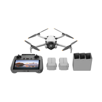
Set up in five minutes
Unpack, power on, follow the interactive checklist, and launch-no calibration needed, not even for LIDAR.
Switch sensors or batteries in seconds
Swap batteries and sensors-from RGB to LIDAR or multispectral-and get back in the air fast. No cables, no tools.
Cover more ground, faster
WingtraRAY flies at up to 22 m/s, so you can cover small or large areas faster-even when time is tight.
Go from field to final files without friction
Efficiency is about reducing manual, error-prone tasks. WingtraRAY sits tightly in a single workflow. No file conversions, no app switching. Just plan, fly, and process - all in one connected system.
One-person field ops. Full team productivity.
WingtraRAY is built for one-person operation - so while they collect data in the field, others can stay focused on analysis or client delivery.
Anyone can fly it. Everyone gets results
WingtraRAY makes it easy for you to collect survey-grade data - no extra training. Follow the checklist, fly, and deliver results to your team fast.
Fly with peace of mind - anywhere
Feel safe flying - even in urban areas - with every feature designed to help you focus on the job, not the risk, so you can get your data right the first time. (Enabled by the parachute add-on.) (Sold Separately).
A parachute built for legal, safe flights
WingtraRAY's parachute deploys automatically, or you can trigger it manually. It's built to protect people below and help you avoid waivers, delays, and legal risks.
Survey over roads and populated areas legally and safely - no waiver, no waiting
• Survey 98% of US land without long or complex FAA approvals
• FAA category 3 OOP certification
• Legally fly over: Roads and infrastructure and Urban and populated areas
WingtraRAY with parachute and Category 3 OOP certification
With FAA-approved safety features, WingtraRAY can legally fly in most of these red zones - no waivers needed. Only a few restricted areas remain (e.g. near airports, national parks or military zones).
Experience the next level of safety and reliability in every flight
NDAA, Blue and Green UAS cleared
WingtraRAY is NDAA, Blue and Green UAS cleared in the US - meeting the highest cybersecurity standards and opening the door to civil government and sensitive projects.
Get the right data the first time
WingtraRAY is built for reliability-from automated pre-flight checks to stable flights in wind-so you leave the site with the data you need, avoiding costly rework.
Avoid obstacles mid-air
Obstacle avoidance gives you extra security during cruise. Detect static obstacles like cranes or trees 100 meters ahead, and fly confidently even when objects aren't on maps.
Return to home safe, even if a battery fails
A backup battery design ensures the drone can return to home safely-even if one battery would fail mid-flight.
Out of sight, but never out of awareness
Thanks to dual telemetry, if the radio link drops, onboard LTE takes over instantly, keeping you connected. You'll always know where the drone is and be future-proof for beyond visual line of sight (BVLOS).
Identify and avoid aircraft
WingtraRAY connects to live airspace data over the cellular network, so you know where other aircraft are and can avoid any conflicts.
Take on more jobs with purpose-built sensors
Deliver more kinds of results - from mm inspection to LIDAR to high-accuracy 3D models - all on one survey-focused platform that's ready to grow with you.