
See Options
Need help? Ask our experts.
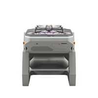
- Dock for X10 -
Position docked drones where the work happens, remotely operate them from anywhere in the world, and get the data your teams need to act; from real-time situational awareness to pre-planned asset inspections.
Work doesn't stop for the weather - neither will Dock.
Heavy-duty reliability
Dock is built to withstand harsh weather related challenges like rain, snow, wind, scorching heat, and freezing cold, so you'll be ready to fly as soon as conditions allow.
• Dock keeps X10 safe in a temperature controlled chamber
• Fly autonomously, and safely, in total darkness with NightSense
Remote OPS - Command drones everywhere, all at once, from anywhere
Remotely operate entire fleets of drones with a detailed picture of the operating area. Learn more about Skydio Remote Ops or DFR Command for public safety.
Go Beyond Visual Line of Sight from first flight.
Real-time airspace and weather data.
Skydio X10's world leading autonomy and ADS-B combined with built-in weather sensors on Dock for X10 provide the Remote Pilot in Command (RPIC) with an accurate picture of both the airspace and conditions on the ground.
Quick launch
Get airborne in 20 seconds.
Designed with safety in mind
Optimize safety with remotely conducted pre-flight checks, warning lights and audible alerts.
Limitless range for when on-site work turns off-site.
• Conduct missions in the most remote locations with Dock's Starlink internet connectivity
• Skydio Connect External Radio maximizes your point-to-point operational range from the Dock
• Skydio Connect Fusion lets drones instantly switch between a point-to-point connection with the dock and 5G/LTE connection for unlimited range
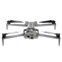
- X10 Drone with Cellular 5G/LTE and Visible Light Navigation Camera -
You've never seen like this before
Skydio X10
The best sensors for a drone this small, piloted by the most advanced AI in the sky. To get the data you need, wherever and whenever you need it.
Visionary cameras to get the job done
Packing more megapixels and better optics than any drone its size, Skydio X10 boasts high resolution visual and radiometric cameras in modular sensor packages. So you can capture the right details for your job.
Unrivaled thermal imaging
Skydio X10 is the first drone ever to integrate a FLIR Boson+ sensor, delivering the highest quality thermal imaging. Capable of resolutions of 640 x 512 px and offering increased sensitivity down to <=30 mK, the X10 delivers more accurate radiometric readings, anytime, any place
Bring the sharpest details to every decision
Off-the-shelf components couldn't deliver the image quality our customers deserve. So, we engineered our own lenses. Achieve unrivaled resolution and superior focus with lenses you won't find anywhere else.
Pixel perfect images
Improve white balance, de-noise photos, extend HDR capabilities and more with sensors backed by the powerful Spectra 480 image signal processor.
Highest quality zoom
Maintain superior image quality even in zoomed-in shots through a compact transition zoom system.
Faster exposure times
Get outstanding images in lowlight, with custom wide aperture f/1.8 and f/2.2 lenses that allow 1.7-3.5x more light than competitors.
Onboard AI. Off-the-charts capability
Fly without limits or learning curves. With a drone that recognizes its surroundings, captures data automatically, and gets smarter over time.
Backed by an onboard NVIDIA Jetson Orin GPU, the X10 harnesses unrivaled computing power to make the right decisions in real-time. Six custom-designed navigation lenses provide 360-degree visibility, eliminating blind spots so you can fly fearlessly in any environment.
• 10X more computing power than the previous generation
• 10X more effective navigation pixels than the previous generation
• GPU Nvidia Onboard NVIDIA Jetson Orin GPU
Fly with ease
Navigate the most complex missions confidently, even in GPS-denied or high EMI environments. With superior AI flight assistance and obstacle avoidance, you no longer need to hire a specialist to get the job done, whether you're in the field with your drone, or piloting from a hundred miles away.
Automate complex missions
Complete targeted inspections automatically, with a new Spatial AI Engine that senses and understands what you're scanning. Efficiently build 2D maps and 3D models onboard, in real time. Or export data to Pix4D, Bentley iTwin Capture, DroneDeploy, or ESRI SiteScan.
Get smarter over time
Skydio X10 is loaded with the computing capacity for its AI data capture and synthesis capabilities to grow over time.
And do it all in the dark - Autonomous flight at night You're not dreaming
Another industry first: Autonomy in the dark
Confidently operate 24/7 in NightSense mode for zero-light navigation - only available with the groundbreaking Skydio X10.
See in the dark
Skydio X10 uses infrared illumination to avoid obstacles, understand its environment, and make the right decisions, every time.
Visible Light Nav Cam and Illuminator
Using visible illumination, the X10 provides bright 360 degree light.
Visible light Module
Conduct autonomous flight in the dark with infrared light.
Ultimate control becomes second nature - Fly however you want
Fly by controller
Plan, execute, and review any mission with the Skydio X10 Controller and Flight Deck, our optimized flight application.
Fly by browser
Launch and fly a drone from a browser with Skydio Remote Flight Deck, to get extra eyes on any situation.
Pass off piloting to a remote operator
Hand over control to an offsite pilot any time with Skydio Remote Flight Deck. The remote pilot can use a browser from any location to seamlessly pick up exactly where the onsite pilot initiated the handoff.
Fly wherever you need
Skydio Connect SL - Fly with a local connection
Fly up to 7.5 miles with Skydio Connect SL, the redesigned direct link from controller to drone. Our proprietary technology maintains a reliable connection in congested areas and enables piloting at distances beyond visual line of sight.
7.5 miles
Count on optimum robustness and range from the Skydio third-generation wireless link.
Skydio Connect 5G/LTE - Fly from your browser, with 5G/LTE
Get unlimited range wherever cellular coverage exists with Skydio Connect 5G/LTE. And now with Remote Flight Deck, you can pilot missions from anywhere on a browser.
Unlimited miles
Extend your range wherever there's a cellular connection.
Skydio Connect MH - Fly in contested environments
Perform with minimal interference in contested environments, with Skydio Connect MH. Global support across six frequency bands, in-flight channel selectability, and AES-256 encryption, enable reliable connectivity anywhere.
Always fly in compliance with the law and in accordance with Skydio Guidelines.
An operator experience forged by thousands of flying hours
Plan, execute, and review every type of mission on the redesigned Skydio Flight Deck app.
A pro-grade interface built from the ground up
Spend less time navigating menus to ensure faster operation during critical missions.
Do more with less distractions
Navigation camera view
See the 3D map the drone is creating in real time to fly with maximum confidence
Modify the interface to suit your needs
See more and do more, with swappable layouts and customizable telemetry
Always see what your drone sees
Maintain visibility of the drone's live preview, even while adjusting settings or receiving notifications
Quickly access key functions
Get immediate access to thermal settings, attachment actions, and AR overlays
See when conditions are changing
Receive notifications to keep track of fluctuating environmental conditions
Precision at your fingertips
Upgraded connectivity, customization options, and a rugged design lets you respond to any situation with total control.
Customizable controls
Get one-touch access to frequently used features.
Improved daytime visibility
With 60% increase in screen brightness.
Ruggedized hardware
IP54 weatherproofing protects from harsh conditions.
Robust connectivity
Supports Skydio Connect for low-latency control from anywhere.
- VT300-L Sensor Package -
VT300-L provides a 64MP narrow module, a 1" wide module with a LED flashlight, and a FLIR Boson+ radiometric module. A great choice for mapping structures and inspections in low light environments.
FLIR Boson+ is a radiometric thermal module offered with the VT300-L sensor packages. This sensor is 40% more sensitive than its predecessor, the FLIR Boson 320x256, so Skydio X10 operators will be able to see much greater detail and get much more precise radiometric measurements than they ever have before.
https://www.skydio.com/legal/limited-warranty
855-463-5902